You are here: Home > Network List > IU - Global Seismograph Network (GSN - IRIS/USGS) Stations List
> Station COR Corvallis, Oregon, USA > Earthquake Result Viewer
COR Corvallis, Oregon, USA - Earthquake Result Viewer
| Earthquake location: |
Near Coast Of Peru |
| Earthquake latitude/longitude: |
-14.4/-76.0 |
| Earthquake time(UTC): |
2011/10/28 (301) 18:54:34 GMT |
| Earthquake Depth: |
24 km |
| Earthquake Magnitude: |
6.5 MB, 6.9 MS, 6.9 MW, 6.9 MW |
| Earthquake Catalog/Contributor: |
WHDF/NEIC |
|
| Network: |
IU Global Seismograph Network (GSN - IRIS/USGS) |
| Station: |
COR Corvallis, Oregon, USA |
| Lat/Lon: |
44.59 N/123.30 W |
| Elevation: |
110 m |
|
| Distance: |
72.8 deg |
| Az: |
326.627 deg |
| Baz: |
131.771 deg |
| Ray Param: |
0.053398307 |
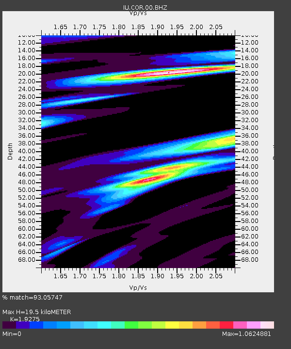
| Estimated Moho Depth: |
19.5 km |
| Estimated Crust Vp/Vs: |
1.93 |
| Assumed Crust Vp: |
6.566 km/s |
| Estimated Crust Vs: |
3.407 km/s |
| Estimated Crust Poisson's Ratio: |
0.32 |
|
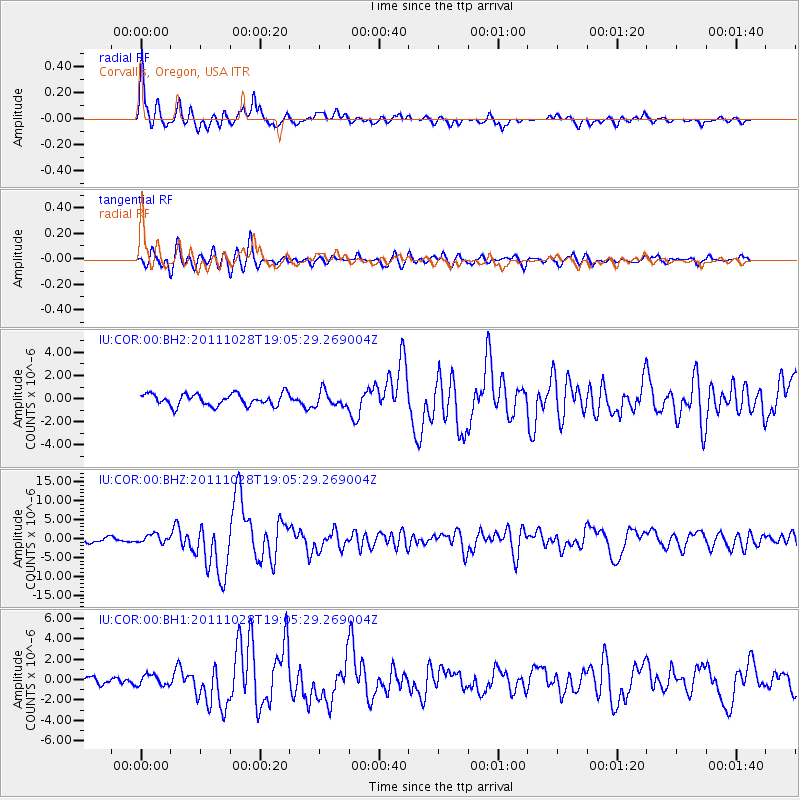
| Radial Match: |
93.05747 % |
| Radial Bump: |
369 |
| Transverse Match: |
79.38159 % |
| Transverse Bump: |
400 |
| SOD ConfigId: |
558545 |
| Insert Time: |
2013-09-19 05:18:55.934 +0000 |
| GWidth: |
2.5 |
| Max Bumps: |
400 |
| Tol: |
0.001 |
|
Signal To Noise
| Channel | StoN | STA | LTA |
| IU:COR:00:BHZ:20111028T19:05:29.269004Z | 2.3958972 | 1.1013848E-6 | 4.5969617E-7 |
| IU:COR:00:BH1:20111028T19:05:29.269004Z | 0.9738022 | 5.223822E-7 | 5.364356E-7 |
| IU:COR:00:BH2:20111028T19:05:29.269004Z | 1.288554 | 6.528593E-7 | 5.066604E-7 |
| Arrivals |
| Ps | 2.8 SECOND |
| PpPs | 8.4 SECOND |
| PsPs/PpSs | 11 SECOND |


