You are here: Home > Network List > IU - Global Seismograph Network (GSN - IRIS/USGS) Stations List
> Station RSSD Black Hills, South Dakota, USA > Earthquake Result Viewer
RSSD Black Hills, South Dakota, USA - Earthquake Result Viewer
| Earthquake location: |
Near Coast Of Peru |
| Earthquake latitude/longitude: |
-14.4/-76.0 |
| Earthquake time(UTC): |
2011/10/28 (301) 18:54:34 GMT |
| Earthquake Depth: |
24 km |
| Earthquake Magnitude: |
6.5 MB, 6.9 MS, 6.9 MW, 6.9 MW |
| Earthquake Catalog/Contributor: |
WHDF/NEIC |
|
| Network: |
IU Global Seismograph Network (GSN - IRIS/USGS) |
| Station: |
RSSD Black Hills, South Dakota, USA |
| Lat/Lon: |
44.12 N/104.04 W |
| Elevation: |
2090 m |
|
| Distance: |
63.7 deg |
| Az: |
337.78 deg |
| Baz: |
149.422 deg |
| Ray Param: |
0.05940537 |
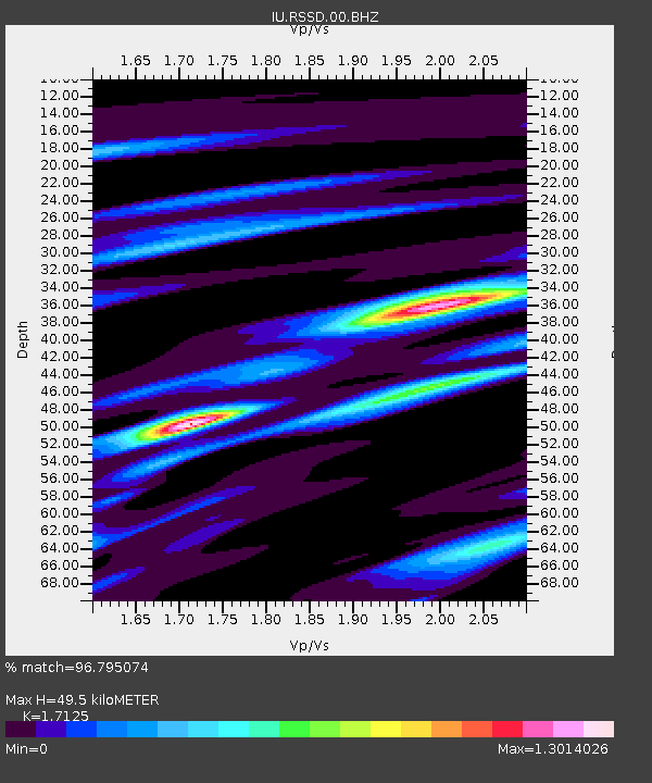
| Estimated Moho Depth: |
49.5 km |
| Estimated Crust Vp/Vs: |
1.71 |
| Assumed Crust Vp: |
6.242 km/s |
| Estimated Crust Vs: |
3.645 km/s |
| Estimated Crust Poisson's Ratio: |
0.24 |
|
| Radial Match: |
96.795074 % |
| Radial Bump: |
291 |
| Transverse Match: |
91.191635 % |
| Transverse Bump: |
400 |
| SOD ConfigId: |
558545 |
| Insert Time: |
2013-09-19 05:19:15.398 +0000 |
| GWidth: |
2.5 |
| Max Bumps: |
400 |
| Tol: |
0.001 |
|
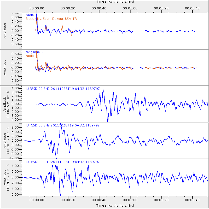
Signal To Noise
| Channel | StoN | STA | LTA |
| IU:RSSD:00:BHZ:20111028T19:04:32.118979Z | 7.5996003 | 1.9062517E-6 | 2.5083577E-7 |
| IU:RSSD:00:BH1:20111028T19:04:32.118979Z | 5.2453136 | 9.878585E-7 | 1.8833163E-7 |
| IU:RSSD:00:BH2:20111028T19:04:32.118979Z | 3.7297988 | 5.762035E-7 | 1.5448649E-7 |
| Arrivals |
| Ps | 5.9 SECOND |
| PpPs | 21 SECOND |
| PsPs/PpSs | 27 SECOND |


