You are here: Home > Network List > IU - Global Seismograph Network (GSN - IRIS/USGS) Stations List
> Station TEIG Tepich, Yucatan, Mexico > Earthquake Result Viewer
TEIG Tepich, Yucatan, Mexico - Earthquake Result Viewer
| Earthquake location: |
Near Coast Of Peru |
| Earthquake latitude/longitude: |
-14.4/-76.0 |
| Earthquake time(UTC): |
2011/10/28 (301) 18:54:34 GMT |
| Earthquake Depth: |
24 km |
| Earthquake Magnitude: |
6.5 MB, 6.9 MS, 6.9 MW, 6.9 MW |
| Earthquake Catalog/Contributor: |
WHDF/NEIC |
|
| Network: |
IU Global Seismograph Network (GSN - IRIS/USGS) |
| Station: |
TEIG Tepich, Yucatan, Mexico |
| Lat/Lon: |
20.23 N/88.28 W |
| Elevation: |
40 m |
|
| Distance: |
36.5 deg |
| Az: |
340.336 deg |
| Baz: |
159.686 deg |
| Ray Param: |
0.07660442 |
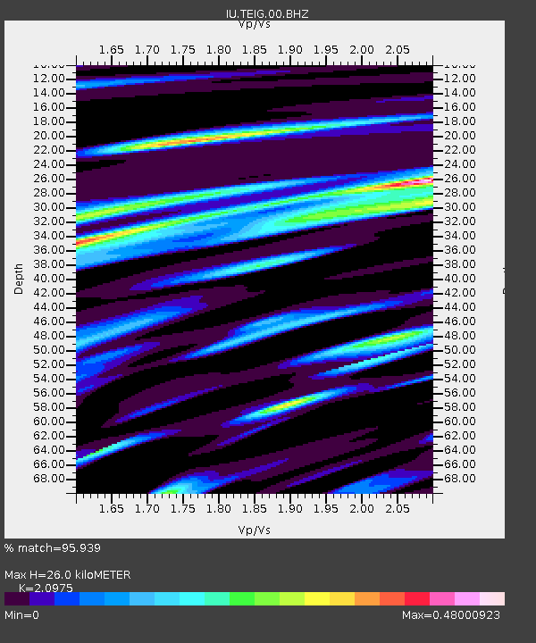
| Estimated Moho Depth: |
26.0 km |
| Estimated Crust Vp/Vs: |
2.10 |
| Assumed Crust Vp: |
5.817 km/s |
| Estimated Crust Vs: |
2.773 km/s |
| Estimated Crust Poisson's Ratio: |
0.35 |
|
| Radial Match: |
95.939 % |
| Radial Bump: |
333 |
| Transverse Match: |
95.67313 % |
| Transverse Bump: |
310 |
| SOD ConfigId: |
558545 |
| Insert Time: |
2013-09-19 05:19:25.999 +0000 |
| GWidth: |
2.5 |
| Max Bumps: |
400 |
| Tol: |
0.001 |
|
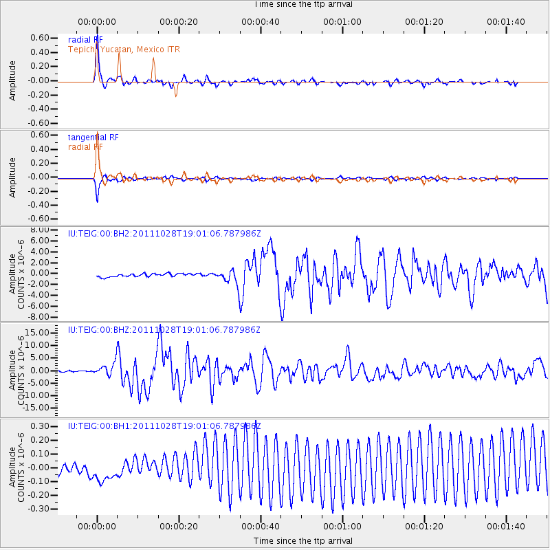
Signal To Noise
| Channel | StoN | STA | LTA |
| IU:TEIG:00:BHZ:20111028T19:01:06.787986Z | 13.7209 | 2.770793E-6 | 2.0193959E-7 |
| IU:TEIG:00:BH1:20111028T19:01:06.787986Z | 2.0114574 | 7.7126245E-8 | 3.834346E-8 |
| IU:TEIG:00:BH2:20111028T19:01:06.787986Z | 4.6908617 | 1.3660045E-6 | 2.9120545E-7 |
| Arrivals |
| Ps | 5.2 SECOND |
| PpPs | 13 SECOND |
| PsPs/PpSs | 18 SECOND |


