You are here: Home > Network List > US - United States National Seismic Network Stations List
> Station GLMI Grayling, Michigan, USA > Earthquake Result Viewer
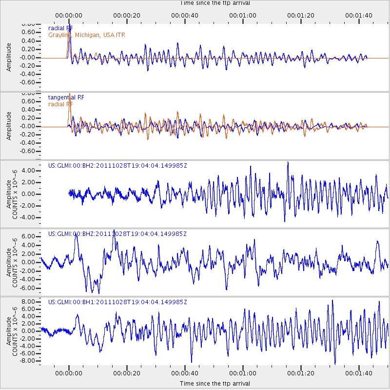
GLMI Grayling, Michigan, USA - Earthquake Result Viewer
*The percent match for this event was below the threshold and hence no stack was calculated.
| Earthquake location: |
Near Coast Of Peru |
| Earthquake latitude/longitude: |
-14.4/-76.0 |
| Earthquake time(UTC): |
2011/10/28 (301) 18:54:34 GMT |
| Earthquake Depth: |
24 km |
| Earthquake Magnitude: |
6.5 MB, 6.9 MS, 6.9 MW, 6.9 MW |
| Earthquake Catalog/Contributor: |
WHDF/NEIC |
|
| Network: |
US United States National Seismic Network |
| Station: |
GLMI Grayling, Michigan, USA |
| Lat/Lon: |
44.82 N/84.62 W |
| Elevation: |
387 m |
|
| Distance: |
59.5 deg |
| Az: |
352.863 deg |
| Baz: |
170.262 deg |
| Ray Param: |
$rayparam |
*The percent match for this event was below the threshold and hence was not used in the summary stack. |
|
| Radial Match: |
73.941475 % |
| Radial Bump: |
400 |
| Transverse Match: |
60.627056 % |
| Transverse Bump: |
400 |
| SOD ConfigId: |
558545 |
| Insert Time: |
2013-09-19 05:20:31.194 +0000 |
| GWidth: |
2.5 |
| Max Bumps: |
400 |
| Tol: |
0.001 |
|
Signal To Noise
| Channel | StoN | STA | LTA |
| US:GLMI:00:BHZ:20111028T19:04:04.149985Z | 5.3382435 | 3.0162014E-6 | 5.6501756E-7 |
| US:GLMI:00:BH1:20111028T19:04:04.149985Z | 2.9923797 | 1.9450827E-6 | 6.50012E-7 |
| US:GLMI:00:BH2:20111028T19:04:04.149985Z | 2.2300928 | 1.2938136E-6 | 5.801614E-7 |
| Arrivals |
| Ps | |
| PpPs | |
| PsPs/PpSs | |


