You are here: Home > Network List > US - United States National Seismic Network Stations List
> Station HLID Hailey, Idaho, USA > Earthquake Result Viewer
HLID Hailey, Idaho, USA - Earthquake Result Viewer
| Earthquake location: |
Near Coast Of Peru |
| Earthquake latitude/longitude: |
-14.4/-76.0 |
| Earthquake time(UTC): |
2011/10/28 (301) 18:54:34 GMT |
| Earthquake Depth: |
24 km |
| Earthquake Magnitude: |
6.5 MB, 6.9 MS, 6.9 MW, 6.9 MW |
| Earthquake Catalog/Contributor: |
WHDF/NEIC |
|
| Network: |
US United States National Seismic Network |
| Station: |
HLID Hailey, Idaho, USA |
| Lat/Lon: |
43.56 N/114.41 W |
| Elevation: |
1772 m |
|
| Distance: |
67.6 deg |
| Az: |
330.727 deg |
| Baz: |
139.332 deg |
| Ray Param: |
0.056834944 |
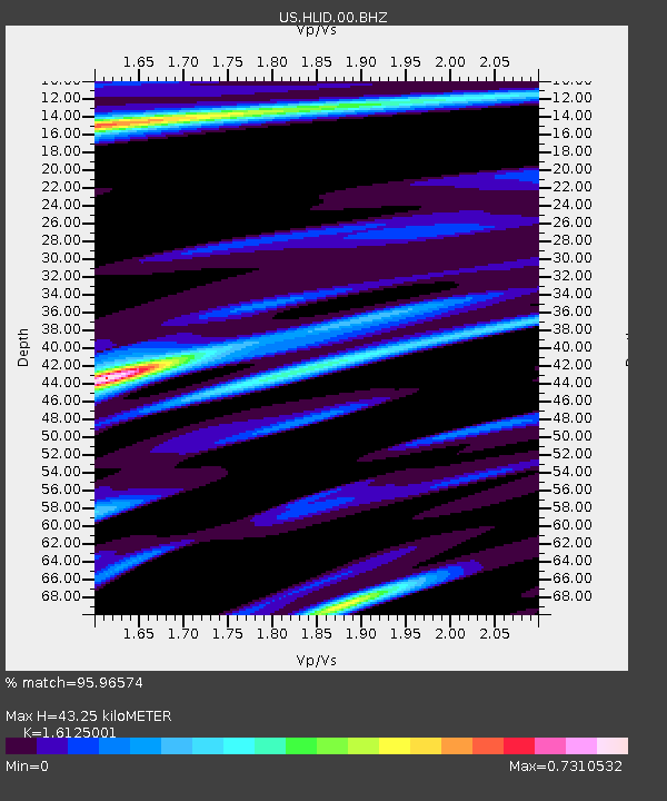
| Estimated Moho Depth: |
43.25 km |
| Estimated Crust Vp/Vs: |
1.61 |
| Assumed Crust Vp: |
6.291 km/s |
| Estimated Crust Vs: |
3.902 km/s |
| Estimated Crust Poisson's Ratio: |
0.19 |
|
| Radial Match: |
95.96574 % |
| Radial Bump: |
265 |
| Transverse Match: |
89.669685 % |
| Transverse Bump: |
400 |
| SOD ConfigId: |
558545 |
| Insert Time: |
2013-09-19 05:20:42.521 +0000 |
| GWidth: |
2.5 |
| Max Bumps: |
400 |
| Tol: |
0.001 |
|

Signal To Noise
| Channel | StoN | STA | LTA |
| US:HLID:00:BHZ:20111028T19:04:57.399009Z | 3.6169538 | 6.7501657E-7 | 1.8662571E-7 |
| US:HLID:00:BH1:20111028T19:04:57.399009Z | 1.0337881 | 1.7100733E-7 | 1.6541817E-7 |
| US:HLID:00:BH2:20111028T19:04:57.399009Z | 0.6791768 | 1.8566699E-7 | 2.7337063E-7 |
| Arrivals |
| Ps | 4.4 SECOND |
| PpPs | 17 SECOND |
| PsPs/PpSs | 22 SECOND |


