You are here: Home > Network List > US - United States National Seismic Network Stations List
> Station LONY Lake Ozonia, New York, USA > Earthquake Result Viewer
LONY Lake Ozonia, New York, USA - Earthquake Result Viewer
| Earthquake location: |
Near Coast Of Peru |
| Earthquake latitude/longitude: |
-14.4/-76.0 |
| Earthquake time(UTC): |
2011/10/28 (301) 18:54:34 GMT |
| Earthquake Depth: |
24 km |
| Earthquake Magnitude: |
6.5 MB, 6.9 MS, 6.9 MW, 6.9 MW |
| Earthquake Catalog/Contributor: |
WHDF/NEIC |
|
| Network: |
US United States National Seismic Network |
| Station: |
LONY Lake Ozonia, New York, USA |
| Lat/Lon: |
44.62 N/74.58 W |
| Elevation: |
440 m |
|
| Distance: |
58.8 deg |
| Az: |
1.155 deg |
| Baz: |
181.567 deg |
| Ray Param: |
0.062584005 |
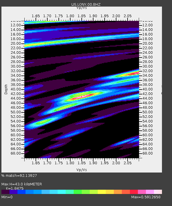
| Estimated Moho Depth: |
43.0 km |
| Estimated Crust Vp/Vs: |
1.85 |
| Assumed Crust Vp: |
6.419 km/s |
| Estimated Crust Vs: |
3.475 km/s |
| Estimated Crust Poisson's Ratio: |
0.29 |
|
| Radial Match: |
92.13927 % |
| Radial Bump: |
257 |
| Transverse Match: |
69.33189 % |
| Transverse Bump: |
344 |
| SOD ConfigId: |
558545 |
| Insert Time: |
2013-09-19 05:21:08.915 +0000 |
| GWidth: |
2.5 |
| Max Bumps: |
400 |
| Tol: |
0.001 |
|
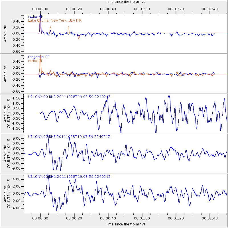
Signal To Noise
| Channel | StoN | STA | LTA |
| US:LONY:00:BHZ:20111028T19:03:59.224021Z | 12.40549 | 4.622865E-6 | 3.7264672E-7 |
| US:LONY:00:BH1:20111028T19:03:59.224021Z | 5.390037 | 2.057606E-6 | 3.8174244E-7 |
| US:LONY:00:BH2:20111028T19:03:59.224021Z | 1.9071138 | 6.7827995E-7 | 3.5565782E-7 |
| Arrivals |
| Ps | 5.9 SECOND |
| PpPs | 18 SECOND |
| PsPs/PpSs | 24 SECOND |


