You are here: Home > Network List > US - United States National Seismic Network Stations List
> Station MSO Missoula, Montana, USA > Earthquake Result Viewer
MSO Missoula, Montana, USA - Earthquake Result Viewer
| Earthquake location: |
Near Coast Of Peru |
| Earthquake latitude/longitude: |
-14.4/-76.0 |
| Earthquake time(UTC): |
2011/10/28 (301) 18:54:34 GMT |
| Earthquake Depth: |
24 km |
| Earthquake Magnitude: |
6.5 MB, 6.9 MS, 6.9 MW, 6.9 MW |
| Earthquake Catalog/Contributor: |
WHDF/NEIC |
|
| Network: |
US United States National Seismic Network |
| Station: |
MSO Missoula, Montana, USA |
| Lat/Lon: |
46.83 N/113.94 W |
| Elevation: |
1264 m |
|
| Distance: |
69.9 deg |
| Az: |
333.257 deg |
| Baz: |
140.585 deg |
| Ray Param: |
0.055333756 |
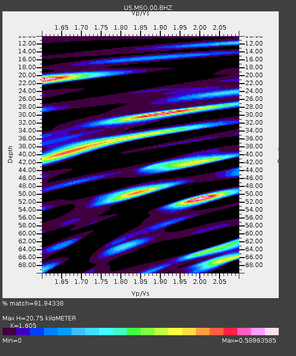
| Estimated Moho Depth: |
20.75 km |
| Estimated Crust Vp/Vs: |
1.61 |
| Assumed Crust Vp: |
6.353 km/s |
| Estimated Crust Vs: |
3.958 km/s |
| Estimated Crust Poisson's Ratio: |
0.18 |
|
| Radial Match: |
91.94338 % |
| Radial Bump: |
400 |
| Transverse Match: |
78.98822 % |
| Transverse Bump: |
400 |
| SOD ConfigId: |
558545 |
| Insert Time: |
2013-09-19 05:21:23.106 +0000 |
| GWidth: |
2.5 |
| Max Bumps: |
400 |
| Tol: |
0.001 |
|
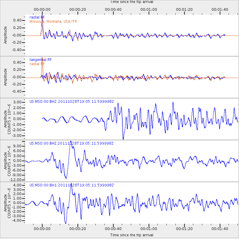
Signal To Noise
| Channel | StoN | STA | LTA |
| US:MSO:00:BHZ:20111028T19:05:11.599998Z | 2.6570861 | 8.165816E-7 | 3.073222E-7 |
| US:MSO:00:BH1:20111028T19:05:11.599998Z | 1.1974465 | 3.901628E-7 | 3.25829E-7 |
| US:MSO:00:BH2:20111028T19:05:11.599998Z | 0.8337549 | 2.7389845E-7 | 3.2851196E-7 |
| Arrivals |
| Ps | 2.1 SECOND |
| PpPs | 8.2 SECOND |
| PsPs/PpSs | 10 SECOND |


