You are here: Home > Network List > US - United States National Seismic Network Stations List
> Station MVCO Mesa Verde, Colorado, USA > Earthquake Result Viewer
MVCO Mesa Verde, Colorado, USA - Earthquake Result Viewer
| Earthquake location: |
Near Coast Of Peru |
| Earthquake latitude/longitude: |
-14.4/-76.0 |
| Earthquake time(UTC): |
2011/10/28 (301) 18:54:34 GMT |
| Earthquake Depth: |
24 km |
| Earthquake Magnitude: |
6.5 MB, 6.9 MS, 6.9 MW, 6.9 MW |
| Earthquake Catalog/Contributor: |
WHDF/NEIC |
|
| Network: |
US United States National Seismic Network |
| Station: |
MVCO Mesa Verde, Colorado, USA |
| Lat/Lon: |
37.21 N/108.50 W |
| Elevation: |
2170 m |
|
| Distance: |
59.8 deg |
| Az: |
330.216 deg |
| Baz: |
142.93 deg |
| Ray Param: |
0.061912913 |
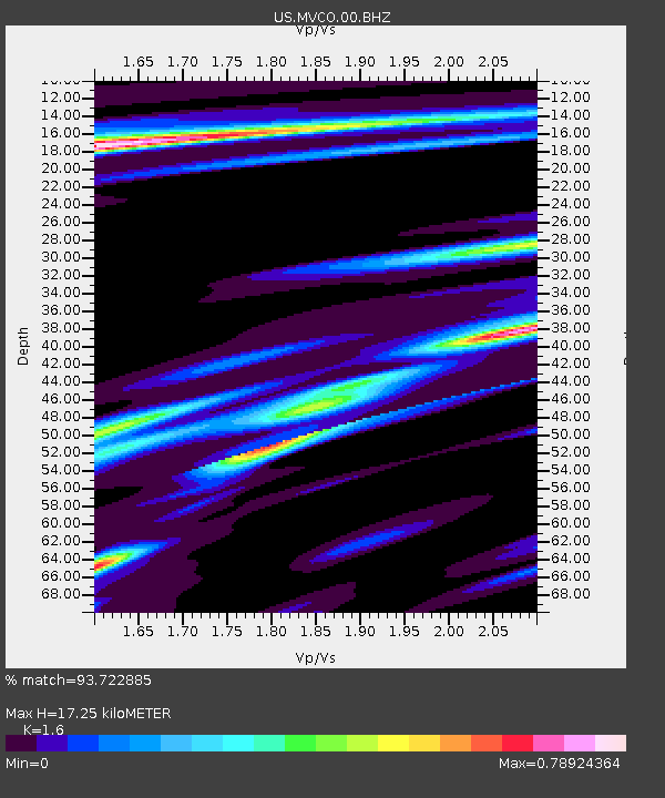
| Estimated Moho Depth: |
17.25 km |
| Estimated Crust Vp/Vs: |
1.60 |
| Assumed Crust Vp: |
6.476 km/s |
| Estimated Crust Vs: |
4.047 km/s |
| Estimated Crust Poisson's Ratio: |
0.18 |
|
| Radial Match: |
93.722885 % |
| Radial Bump: |
288 |
| Transverse Match: |
88.41122 % |
| Transverse Bump: |
400 |
| SOD ConfigId: |
558545 |
| Insert Time: |
2013-09-19 05:21:27.342 +0000 |
| GWidth: |
2.5 |
| Max Bumps: |
400 |
| Tol: |
0.001 |
|
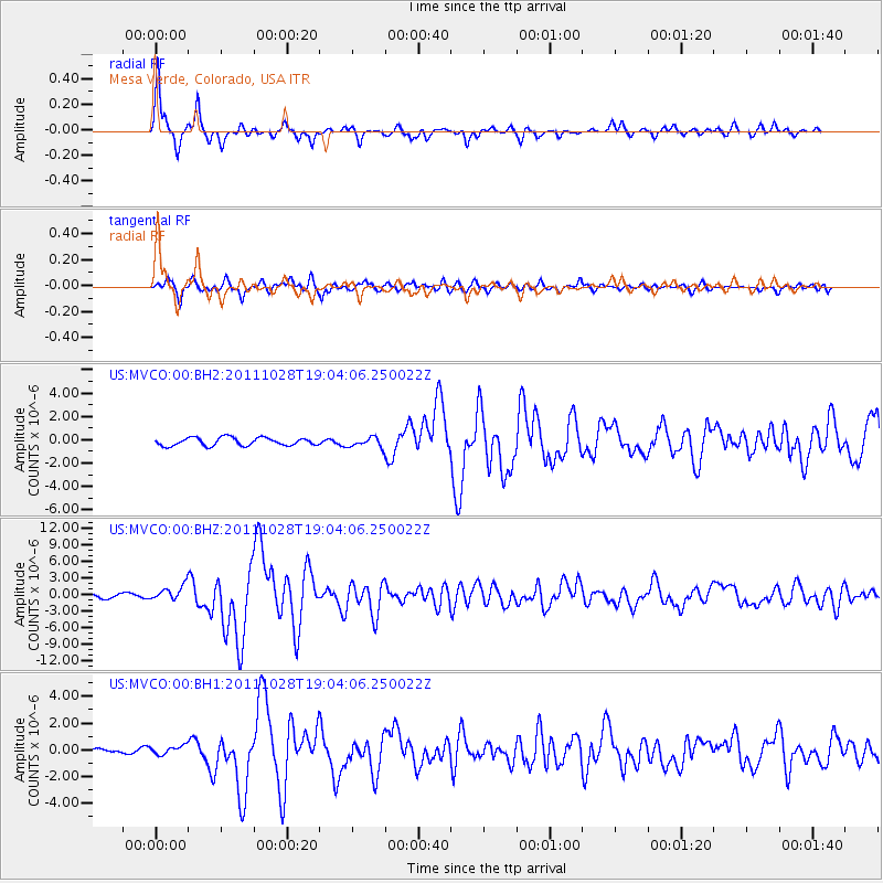
Signal To Noise
| Channel | StoN | STA | LTA |
| US:MVCO:00:BHZ:20111028T19:04:06.250022Z | 4.9822702 | 1.3346812E-6 | 2.6788618E-7 |
| US:MVCO:00:BH1:20111028T19:04:06.250022Z | 1.1905224 | 3.3886548E-7 | 2.8463595E-7 |
| US:MVCO:00:BH2:20111028T19:04:06.250022Z | 1.217495 | 4.144489E-7 | 3.4041116E-7 |
| Arrivals |
| Ps | 1.7 SECOND |
| PpPs | 6.6 SECOND |
| PsPs/PpSs | 8.3 SECOND |


