You are here: Home > Network List > US - United States National Seismic Network Stations List
> Station SDCO Great Sand Dunes National Park, Colorado, USA > Earthquake Result Viewer
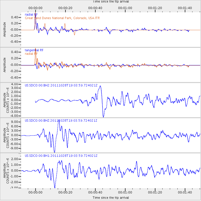
SDCO Great Sand Dunes National Park, Colorado, USA - Earthquake Result Viewer

| Earthquake location: |
Near Coast Of Peru |
| Earthquake latitude/longitude: |
-14.4/-76.0 |
| Earthquake time(UTC): |
2011/10/28 (301) 18:54:34 GMT |
| Earthquake Depth: |
24 km |
| Earthquake Magnitude: |
6.5 MB, 6.9 MS, 6.9 MW, 6.9 MW |
| Earthquake Catalog/Contributor: |
WHDF/NEIC |
|
| Network: |
US United States National Seismic Network |
| Station: |
SDCO Great Sand Dunes National Park, Colorado, USA |
| Lat/Lon: |
37.75 N/105.50 W |
| Elevation: |
2569 m |
|
| Distance: |
58.9 deg |
| Az: |
332.833 deg |
| Baz: |
146.082 deg |
| Ray Param: |
0.06253758 |
| Estimated Moho Depth: |
16.75 km |
| Estimated Crust Vp/Vs: |
1.60 |
| Assumed Crust Vp: |
6.316 km/s |
| Estimated Crust Vs: |
3.947 km/s |
| Estimated Crust Poisson's Ratio: |
0.18 |
|
| Radial Match: |
95.757545 % |
| Radial Bump: |
264 |
| Transverse Match: |
86.152596 % |
| Transverse Bump: |
399 |
| SOD ConfigId: |
558545 |
| Insert Time: |
2013-09-19 05:21:51.104 +0000 |
| GWidth: |
2.5 |
| Max Bumps: |
400 |
| Tol: |
0.001 |
|
Signal To Noise
| Channel | StoN | STA | LTA |
| US:SDCO:00:BHZ:20111028T19:03:59.724021Z | 4.901035 | 1.0366095E-6 | 2.115083E-7 |
| US:SDCO:00:BH1:20111028T19:03:59.724021Z | 1.5688256 | 2.968371E-7 | 1.8920976E-7 |
| US:SDCO:00:BH2:20111028T19:03:59.724021Z | 1.7133329 | 3.3318955E-7 | 1.9446867E-7 |
| Arrivals |
| Ps | 1.7 SECOND |
| PpPs | 6.5 SECOND |
| PsPs/PpSs | 8.2 SECOND |


