You are here: Home > Network List > II - Global Seismograph Network (GSN - IRIS/IDA) Stations List
> Station WRAB Tennant Creek, NT, Australia > Earthquake Result Viewer
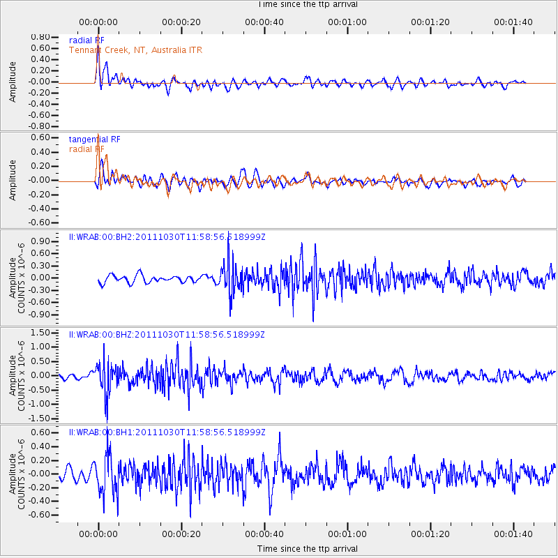
WRAB Tennant Creek, NT, Australia - Earthquake Result Viewer
*The percent match for this event was below the threshold and hence no stack was calculated.
| Earthquake location: |
Southern Sumatra, Indonesia |
| Earthquake latitude/longitude: |
-3.2/101.3 |
| Earthquake time(UTC): |
2011/10/30 (303) 11:52:27 GMT |
| Earthquake Depth: |
36 km |
| Earthquake Magnitude: |
5.6 MB, 5.1 MS, 5.6 MW, 5.6 MW |
| Earthquake Catalog/Contributor: |
WHDF/NEIC |
|
| Network: |
II Global Seismograph Network (GSN - IRIS/IDA) |
| Station: |
WRAB Tennant Creek, NT, Australia |
| Lat/Lon: |
19.93 S/134.36 E |
| Elevation: |
366 m |
|
| Distance: |
36.2 deg |
| Az: |
119.832 deg |
| Baz: |
292.987 deg |
| Ray Param: |
$rayparam |
*The percent match for this event was below the threshold and hence was not used in the summary stack. |
|
| Radial Match: |
53.160465 % |
| Radial Bump: |
400 |
| Transverse Match: |
59.311657 % |
| Transverse Bump: |
400 |
| SOD ConfigId: |
558545 |
| Insert Time: |
2013-09-19 05:30:25.543 +0000 |
| GWidth: |
2.5 |
| Max Bumps: |
400 |
| Tol: |
0.001 |
|
Signal To Noise
| Channel | StoN | STA | LTA |
| II:WRAB:00:BHZ:20111030T11:58:56.518999Z | 4.6604342 | 5.30424E-7 | 1.1381429E-7 |
| II:WRAB:00:BH1:20111030T11:58:56.518999Z | 3.553841 | 2.8512568E-7 | 8.0230286E-8 |
| II:WRAB:00:BH2:20111030T11:58:56.518999Z | 4.291777 | 3.7741918E-7 | 8.7940066E-8 |
| Arrivals |
| Ps | |
| PpPs | |
| PsPs/PpSs | |


