You are here: Home > Network List > II - Global Seismograph Network (GSN - IRIS/IDA) Stations List
> Station WRAB Tennant Creek, NT, Australia > Earthquake Result Viewer
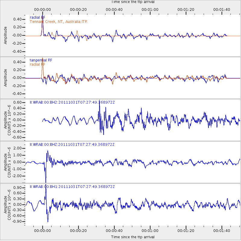
WRAB Tennant Creek, NT, Australia - Earthquake Result Viewer
*The percent match for this event was below the threshold and hence no stack was calculated.
| Earthquake location: |
Rat Islands, Aleutian Islands |
| Earthquake latitude/longitude: |
52.4/177.9 |
| Earthquake time(UTC): |
2011/10/31 (304) 07:16:21 GMT |
| Earthquake Depth: |
159 km |
| Earthquake Magnitude: |
5.8 MB, 5.8 MW, 5.9 MW |
| Earthquake Catalog/Contributor: |
WHDF/NEIC |
|
| Network: |
II Global Seismograph Network (GSN - IRIS/IDA) |
| Station: |
WRAB Tennant Creek, NT, Australia |
| Lat/Lon: |
19.93 S/134.36 E |
| Elevation: |
366 m |
|
| Distance: |
81.4 deg |
| Az: |
220.989 deg |
| Baz: |
25.309 deg |
| Ray Param: |
$rayparam |
*The percent match for this event was below the threshold and hence was not used in the summary stack. |
|
| Radial Match: |
75.61784 % |
| Radial Bump: |
290 |
| Transverse Match: |
70.459305 % |
| Transverse Bump: |
389 |
| SOD ConfigId: |
558545 |
| Insert Time: |
2013-09-19 05:38:26.002 +0000 |
| GWidth: |
2.5 |
| Max Bumps: |
400 |
| Tol: |
0.001 |
|
Signal To Noise
| Channel | StoN | STA | LTA |
| II:WRAB:00:BHZ:20111031T07:27:49.368972Z | 7.855472 | 9.587125E-7 | 1.220439E-7 |
| II:WRAB:00:BH1:20111031T07:27:49.368972Z | 4.0178084 | 4.1302232E-7 | 1.0279791E-7 |
| II:WRAB:00:BH2:20111031T07:27:49.368972Z | 2.9591048 | 2.2479752E-7 | 7.596808E-8 |
| Arrivals |
| Ps | |
| PpPs | |
| PsPs/PpSs | |


