You are here: Home > Network List > IU - Global Seismograph Network (GSN - IRIS/USGS) Stations List
> Station JOHN Johnston Island, USA > Earthquake Result Viewer
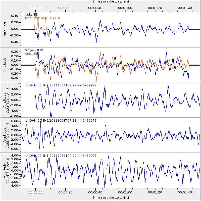
JOHN Johnston Island, USA - Earthquake Result Viewer
*The percent match for this event was below the threshold and hence no stack was calculated.
| Earthquake location: |
Rat Islands, Aleutian Islands |
| Earthquake latitude/longitude: |
52.4/177.9 |
| Earthquake time(UTC): |
2011/10/31 (304) 07:16:21 GMT |
| Earthquake Depth: |
159 km |
| Earthquake Magnitude: |
5.8 MB, 5.8 MW, 5.9 MW |
| Earthquake Catalog/Contributor: |
WHDF/NEIC |
|
| Network: |
IU Global Seismograph Network (GSN - IRIS/USGS) |
| Station: |
JOHN Johnston Island, USA |
| Lat/Lon: |
16.73 N/169.53 W |
| Elevation: |
2.0 m |
|
| Distance: |
36.9 deg |
| Az: |
159.734 deg |
| Baz: |
347.193 deg |
| Ray Param: |
$rayparam |
*The percent match for this event was below the threshold and hence was not used in the summary stack. |
|
| Radial Match: |
64.006004 % |
| Radial Bump: |
400 |
| Transverse Match: |
60.227844 % |
| Transverse Bump: |
400 |
| SOD ConfigId: |
558545 |
| Insert Time: |
2013-09-19 05:38:51.909 +0000 |
| GWidth: |
2.5 |
| Max Bumps: |
400 |
| Tol: |
0.001 |
|
Signal To Noise
| Channel | StoN | STA | LTA |
| IU:JOHN:00:BHZ:20111031T07:22:44.643997Z | 1.9168886 | 3.2619632E-6 | 1.7016968E-6 |
| IU:JOHN:00:BH1:20111031T07:22:44.643997Z | 1.0434072 | 1.9379597E-6 | 1.8573378E-6 |
| IU:JOHN:00:BH2:20111031T07:22:44.643997Z | 0.58939517 | 1.530417E-6 | 2.596589E-6 |
| Arrivals |
| Ps | |
| PpPs | |
| PsPs/PpSs | |


