You are here: Home > Network List > IU - Global Seismograph Network (GSN - IRIS/USGS) Stations List
> Station MAJO Matsushiro, Japan > Earthquake Result Viewer
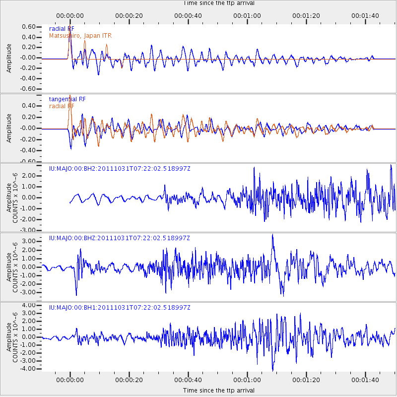
MAJO Matsushiro, Japan - Earthquake Result Viewer
*The percent match for this event was below the threshold and hence no stack was calculated.
| Earthquake location: |
Rat Islands, Aleutian Islands |
| Earthquake latitude/longitude: |
52.4/177.9 |
| Earthquake time(UTC): |
2011/10/31 (304) 07:16:21 GMT |
| Earthquake Depth: |
159 km |
| Earthquake Magnitude: |
5.8 MB, 5.8 MW, 5.9 MW |
| Earthquake Catalog/Contributor: |
WHDF/NEIC |
|
| Network: |
IU Global Seismograph Network (GSN - IRIS/USGS) |
| Station: |
MAJO Matsushiro, Japan |
| Lat/Lon: |
36.55 N/138.20 E |
| Elevation: |
405 m |
|
| Distance: |
32.0 deg |
| Az: |
256.277 deg |
| Baz: |
47.707 deg |
| Ray Param: |
$rayparam |
*The percent match for this event was below the threshold and hence was not used in the summary stack. |
|
| Radial Match: |
71.0488 % |
| Radial Bump: |
400 |
| Transverse Match: |
63.7952 % |
| Transverse Bump: |
400 |
| SOD ConfigId: |
558545 |
| Insert Time: |
2013-09-19 05:39:01.601 +0000 |
| GWidth: |
2.5 |
| Max Bumps: |
400 |
| Tol: |
0.001 |
|
Signal To Noise
| Channel | StoN | STA | LTA |
| IU:MAJO:00:BHZ:20111031T07:22:02.518997Z | 5.2252245 | 1.1310207E-6 | 2.1645397E-7 |
| IU:MAJO:00:BH1:20111031T07:22:02.518997Z | 2.7274706 | 4.6210798E-7 | 1.694273E-7 |
| IU:MAJO:00:BH2:20111031T07:22:02.518997Z | 1.7589866 | 4.225274E-7 | 2.402107E-7 |
| Arrivals |
| Ps | |
| PpPs | |
| PsPs/PpSs | |


