You are here: Home > Network List > US - United States National Seismic Network Stations List
> Station BLA Blacksburg, Virginia, USA > Earthquake Result Viewer
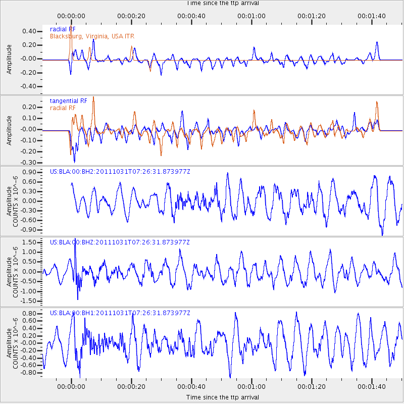
BLA Blacksburg, Virginia, USA - Earthquake Result Viewer
*The percent match for this event was below the threshold and hence no stack was calculated.
| Earthquake location: |
Rat Islands, Aleutian Islands |
| Earthquake latitude/longitude: |
52.4/177.9 |
| Earthquake time(UTC): |
2011/10/31 (304) 07:16:21 GMT |
| Earthquake Depth: |
159 km |
| Earthquake Magnitude: |
5.8 MB, 5.8 MW, 5.9 MW |
| Earthquake Catalog/Contributor: |
WHDF/NEIC |
|
| Network: |
US United States National Seismic Network |
| Station: |
BLA Blacksburg, Virginia, USA |
| Lat/Lon: |
37.21 N/80.42 W |
| Elevation: |
634 m |
|
| Distance: |
67.9 deg |
| Az: |
57.582 deg |
| Baz: |
319.582 deg |
| Ray Param: |
$rayparam |
*The percent match for this event was below the threshold and hence was not used in the summary stack. |
|
| Radial Match: |
46.69129 % |
| Radial Bump: |
400 |
| Transverse Match: |
64.69456 % |
| Transverse Bump: |
400 |
| SOD ConfigId: |
558545 |
| Insert Time: |
2013-09-19 05:39:55.986 +0000 |
| GWidth: |
2.5 |
| Max Bumps: |
400 |
| Tol: |
0.001 |
|
Signal To Noise
| Channel | StoN | STA | LTA |
| US:BLA:00:BHZ:20111031T07:26:31.873977Z | 2.688488 | 6.141292E-7 | 2.2842922E-7 |
| US:BLA:00:BH1:20111031T07:26:31.873977Z | 1.3824986 | 4.8725474E-7 | 3.52445E-7 |
| US:BLA:00:BH2:20111031T07:26:31.873977Z | 1.2985893 | 3.7099164E-7 | 2.8568817E-7 |
| Arrivals |
| Ps | |
| PpPs | |
| PsPs/PpSs | |


