You are here: Home > Network List > US - United States National Seismic Network Stations List
> Station BOZ Bozeman, Montana, USA > Earthquake Result Viewer
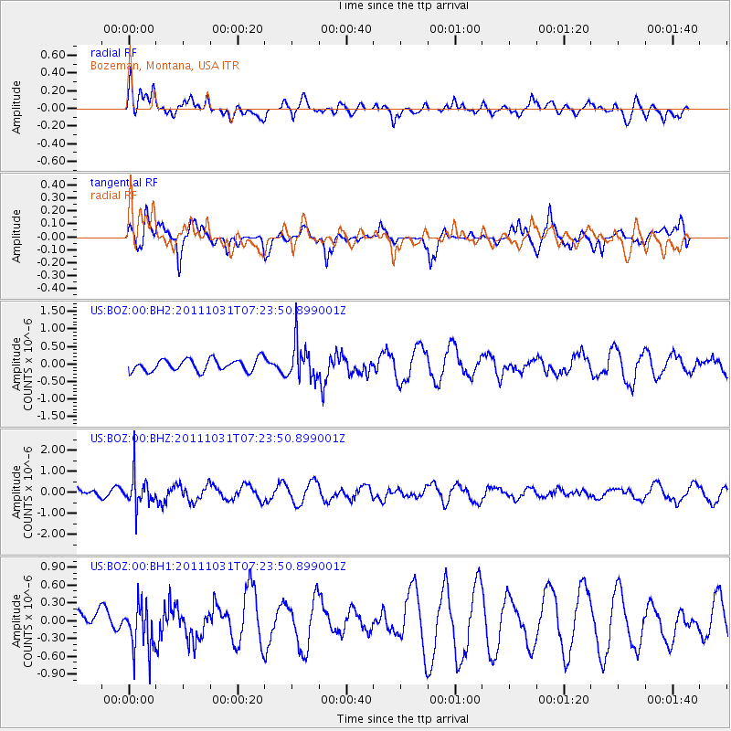
BOZ Bozeman, Montana, USA - Earthquake Result Viewer
*The percent match for this event was below the threshold and hence no stack was calculated.
| Earthquake location: |
Rat Islands, Aleutian Islands |
| Earthquake latitude/longitude: |
52.4/177.9 |
| Earthquake time(UTC): |
2011/10/31 (304) 07:16:21 GMT |
| Earthquake Depth: |
159 km |
| Earthquake Magnitude: |
5.8 MB, 5.8 MW, 5.9 MW |
| Earthquake Catalog/Contributor: |
WHDF/NEIC |
|
| Network: |
US United States National Seismic Network |
| Station: |
BOZ Bozeman, Montana, USA |
| Lat/Lon: |
45.65 N/111.63 W |
| Elevation: |
1589 m |
|
| Distance: |
45.0 deg |
| Az: |
69.17 deg |
| Baz: |
305.214 deg |
| Ray Param: |
$rayparam |
*The percent match for this event was below the threshold and hence was not used in the summary stack. |
|
| Radial Match: |
51.576996 % |
| Radial Bump: |
400 |
| Transverse Match: |
46.44157 % |
| Transverse Bump: |
349 |
| SOD ConfigId: |
558545 |
| Insert Time: |
2013-09-19 05:40:00.858 +0000 |
| GWidth: |
2.5 |
| Max Bumps: |
400 |
| Tol: |
0.001 |
|
Signal To Noise
| Channel | StoN | STA | LTA |
| US:BOZ:00:BHZ:20111031T07:23:50.899001Z | 3.1722095 | 7.2766227E-7 | 2.2938657E-7 |
| US:BOZ:00:BH1:20111031T07:23:50.899001Z | 1.7288342 | 3.9912834E-7 | 2.3086561E-7 |
| US:BOZ:00:BH2:20111031T07:23:50.899001Z | 2.9476538 | 5.0199225E-7 | 1.7030231E-7 |
| Arrivals |
| Ps | |
| PpPs | |
| PsPs/PpSs | |


