You are here: Home > Network List > CI - Caltech Regional Seismic Network Stations List
> Station LRL Laurel Mtn Radio Fac, Ridgecrest, CA, USA > Earthquake Result Viewer
LRL Laurel Mtn Radio Fac, Ridgecrest, CA, USA - Earthquake Result Viewer
| Earthquake location: |
Northern Peru |
| Earthquake latitude/longitude: |
-5.7/-76.4 |
| Earthquake time(UTC): |
2005/09/26 (269) 01:55:37 GMT |
| Earthquake Depth: |
115 km |
| Earthquake Magnitude: |
6.7 MB, 7.5 MW, 7.5 MW |
| Earthquake Catalog/Contributor: |
WHDF/NEIC |
|
| Network: |
CI Caltech Regional Seismic Network |
| Station: |
LRL Laurel Mtn Radio Fac, Ridgecrest, CA, USA |
| Lat/Lon: |
35.48 N/117.68 W |
| Elevation: |
1340 m |
|
| Distance: |
56.4 deg |
| Az: |
319.715 deg |
| Baz: |
127.963 deg |
| Ray Param: |
0.06381908 |
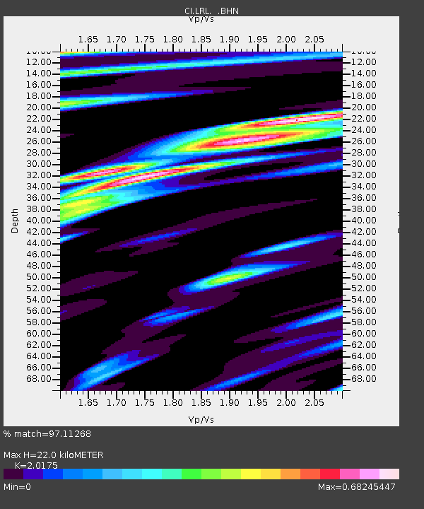
| Estimated Moho Depth: |
22.0 km |
| Estimated Crust Vp/Vs: |
2.02 |
| Assumed Crust Vp: |
6.276 km/s |
| Estimated Crust Vs: |
3.111 km/s |
| Estimated Crust Poisson's Ratio: |
0.34 |
|
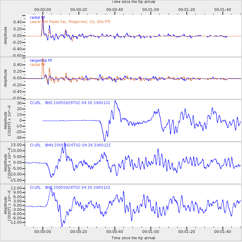
| Radial Match: |
97.11268 % |
| Radial Bump: |
400 |
| Transverse Match: |
90.81469 % |
| Transverse Bump: |
400 |
| SOD ConfigId: |
2564 |
| Insert Time: |
2010-02-25 20:39:53.945 +0000 |
| GWidth: |
2.5 |
| Max Bumps: |
400 |
| Tol: |
0.001 |
|
Signal To Noise
| Channel | StoN | STA | LTA |
| CI:LRL: :BHN:20050926T02:04:36.396013Z | 26.524178 | 4.8242255E-6 | 1.818803E-7 |
| CI:LRL: :BHE:20050926T02:04:36.396013Z | 27.150606 | 5.5505634E-6 | 2.0443608E-7 |
| CI:LRL: :BHZ:20050926T02:04:36.396013Z | 54.025326 | 1.6110838E-5 | 2.98209E-7 |
| Arrivals |
| Ps | 3.7 SECOND |
| PpPs | 10 SECOND |
| PsPs/PpSs | 14 SECOND |


