You are here: Home > Network List > US - United States National Seismic Network Stations List
> Station DGMT Dagmar, Montana, USA > Earthquake Result Viewer
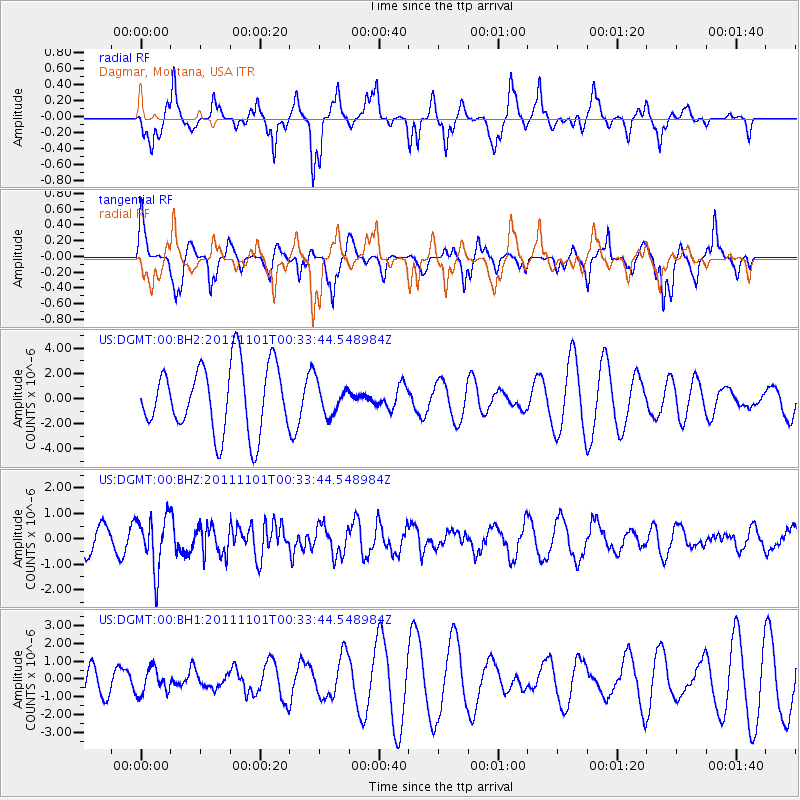
DGMT Dagmar, Montana, USA - Earthquake Result Viewer
*The percent match for this event was below the threshold and hence no stack was calculated.
| Earthquake location: |
Northern Xinjiang, China |
| Earthquake latitude/longitude: |
43.6/82.4 |
| Earthquake time(UTC): |
2011/11/01 (305) 00:21:28 GMT |
| Earthquake Depth: |
28 km |
| Earthquake Magnitude: |
6.0 MB, 5.4 MS, 5.6 MW, 5.4 MW |
| Earthquake Catalog/Contributor: |
WHDF/NEIC |
|
| Network: |
US United States National Seismic Network |
| Station: |
DGMT Dagmar, Montana, USA |
| Lat/Lon: |
48.47 N/104.20 W |
| Elevation: |
0.0 m |
|
| Distance: |
88.1 deg |
| Az: |
4.411 deg |
| Baz: |
355.188 deg |
| Ray Param: |
$rayparam |
*The percent match for this event was below the threshold and hence was not used in the summary stack. |
|
| Radial Match: |
80.012985 % |
| Radial Bump: |
321 |
| Transverse Match: |
40.718254 % |
| Transverse Bump: |
237 |
| SOD ConfigId: |
558545 |
| Insert Time: |
2013-09-19 05:45:41.183 +0000 |
| GWidth: |
2.5 |
| Max Bumps: |
400 |
| Tol: |
0.001 |
|
Signal To Noise
| Channel | StoN | STA | LTA |
| US:DGMT:00:BHZ:20111101T00:33:44.548984Z | 2.6644056 | 1.0418785E-6 | 3.9103597E-7 |
| US:DGMT:00:BH1:20111101T00:33:44.548984Z | 0.67343515 | 7.029526E-7 | 1.0438312E-6 |
| US:DGMT:00:BH2:20111101T00:33:44.548984Z | 0.46891987 | 1.2488451E-6 | 2.6632376E-6 |
| Arrivals |
| Ps | |
| PpPs | |
| PsPs/PpSs | |


