You are here: Home > Network List > CN - Canadian National Seismograph Network Stations List
> Station INK INUVIK, NT, CANADA.ANADA > Earthquake Result Viewer
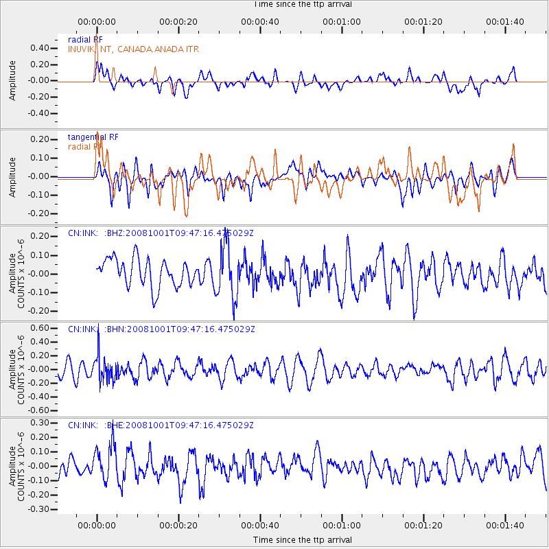
INK INUVIK, NT, CANADA.ANADA - Earthquake Result Viewer
*The percent match for this event was below the threshold and hence no stack was calculated.
| Earthquake location: |
Southeast Of Honshu, Japan |
| Earthquake latitude/longitude: |
30.2/138.8 |
| Earthquake time(UTC): |
2008/10/01 (275) 09:38:12 GMT |
| Earthquake Depth: |
414 km |
| Earthquake Magnitude: |
5.7 MW, 5.1 MB, 5.7 MW |
| Earthquake Catalog/Contributor: |
WHDF/NEIC |
|
| Network: |
CN Canadian National Seismograph Network |
| Station: |
INK INUVIK, NT, CANADA.ANADA |
| Lat/Lon: |
68.31 N/133.52 W |
| Elevation: |
40 m |
|
| Distance: |
61.5 deg |
| Az: |
25.004 deg |
| Baz: |
280.066 deg |
| Ray Param: |
$rayparam |
*The percent match for this event was below the threshold and hence was not used in the summary stack. |
|
| Radial Match: |
52.18227 % |
| Radial Bump: |
400 |
| Transverse Match: |
39.446686 % |
| Transverse Bump: |
400 |
| SOD ConfigId: |
2560 |
| Insert Time: |
2010-02-27 06:32:06.250 +0000 |
| GWidth: |
2.5 |
| Max Bumps: |
400 |
| Tol: |
0.001 |
|
Signal To Noise
| Channel | StoN | STA | LTA |
| CN:INK: :BHN:20081001T09:47:16.475029Z | 2.0707998 | 1.8623776E-7 | 8.9935185E-8 |
| CN:INK: :BHE:20081001T09:47:16.475029Z | 1.5932164 | 1.2423563E-7 | 7.797787E-8 |
| CN:INK: :BHZ:20081001T09:47:16.475029Z | 1.9506999 | 1.424502E-7 | 7.302518E-8 |
| Arrivals |
| Ps | |
| PpPs | |
| PsPs/PpSs | |


