You are here: Home > Network List > CN - Canadian National Seismograph Network Stations List
> Station INK INUVIK, NT, CANADA.ANADA > Earthquake Result Viewer
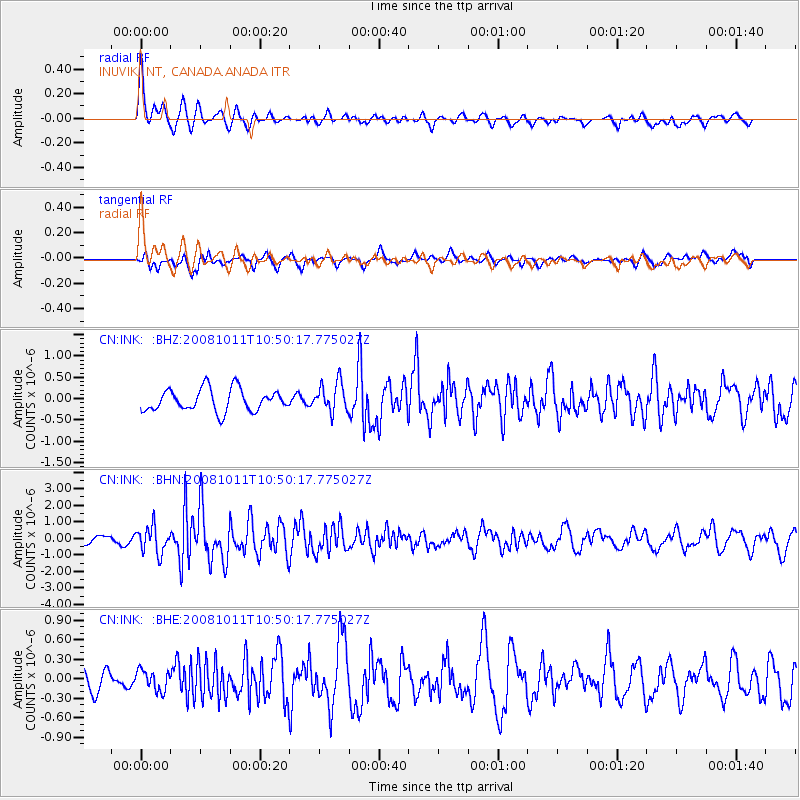
INK INUVIK, NT, CANADA.ANADA - Earthquake Result Viewer
*The percent match for this event was below the threshold and hence no stack was calculated.
| Earthquake location: |
Virgin Islands |
| Earthquake latitude/longitude: |
19.2/-64.8 |
| Earthquake time(UTC): |
2008/10/11 (285) 10:40:14 GMT |
| Earthquake Depth: |
23 km |
| Earthquake Magnitude: |
6.1 MB, 5.9 MS, 6.1 MW, 6.0 MW |
| Earthquake Catalog/Contributor: |
WHDF/NEIC |
|
| Network: |
CN Canadian National Seismograph Network |
| Station: |
INK INUVIK, NT, CANADA.ANADA |
| Lat/Lon: |
68.31 N/133.52 W |
| Elevation: |
40 m |
|
| Distance: |
64.5 deg |
| Az: |
337.433 deg |
| Baz: |
102.65 deg |
| Ray Param: |
$rayparam |
*The percent match for this event was below the threshold and hence was not used in the summary stack. |
|
| Radial Match: |
71.661804 % |
| Radial Bump: |
400 |
| Transverse Match: |
55.74154 % |
| Transverse Bump: |
400 |
| SOD ConfigId: |
2560 |
| Insert Time: |
2010-02-27 06:32:07.737 +0000 |
| GWidth: |
2.5 |
| Max Bumps: |
400 |
| Tol: |
0.001 |
|
Signal To Noise
| Channel | StoN | STA | LTA |
| CN:INK: :BHN:20081011T10:50:17.775027Z | 3.6496115 | 7.980155E-7 | 2.1865765E-7 |
| CN:INK: :BHE:20081011T10:50:17.775027Z | 0.6661685 | 1.5800285E-7 | 2.3718151E-7 |
| CN:INK: :BHZ:20081011T10:50:17.775027Z | 1.3507915 | 3.466545E-7 | 2.5663067E-7 |
| Arrivals |
| Ps | |
| PpPs | |
| PsPs/PpSs | |


