You are here: Home > Network List > CN - Canadian National Seismograph Network Stations List
> Station INK INUVIK, NT, CANADA.ANADA > Earthquake Result Viewer
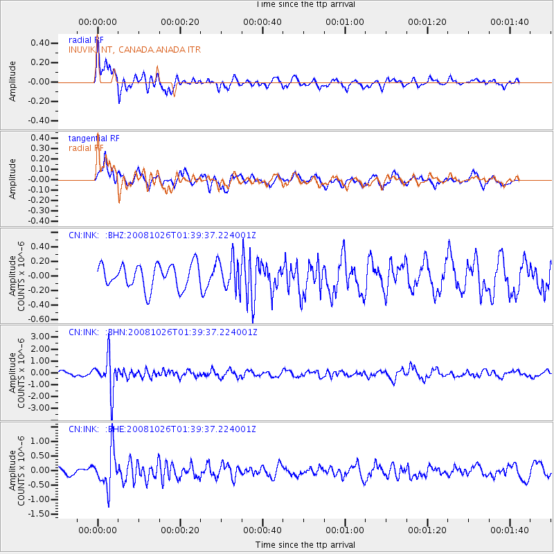
INK INUVIK, NT, CANADA.ANADA - Earthquake Result Viewer
*The percent match for this event was below the threshold and hence no stack was calculated.
| Earthquake location: |
Hindu Kush Region, Afghanistan |
| Earthquake latitude/longitude: |
36.5/70.7 |
| Earthquake time(UTC): |
2008/10/26 (300) 01:28:56 GMT |
| Earthquake Depth: |
210 km |
| Earthquake Magnitude: |
5.5 MB, 5.7 MW, 5.7 MW |
| Earthquake Catalog/Contributor: |
WHDF/NEIC |
|
| Network: |
CN Canadian National Seismograph Network |
| Station: |
INK INUVIK, NT, CANADA.ANADA |
| Lat/Lon: |
68.31 N/133.52 W |
| Elevation: |
40 m |
|
| Distance: |
74.0 deg |
| Az: |
9.126 deg |
| Baz: |
339.893 deg |
| Ray Param: |
$rayparam |
*The percent match for this event was below the threshold and hence was not used in the summary stack. |
|
| Radial Match: |
67.82414 % |
| Radial Bump: |
400 |
| Transverse Match: |
61.524467 % |
| Transverse Bump: |
400 |
| SOD ConfigId: |
2560 |
| Insert Time: |
2010-02-27 06:32:10.127 +0000 |
| GWidth: |
2.5 |
| Max Bumps: |
400 |
| Tol: |
0.001 |
|
Signal To Noise
| Channel | StoN | STA | LTA |
| CN:INK: :BHN:20081026T01:39:37.224001Z | 3.8048456 | 1.5251773E-6 | 4.008513E-7 |
| CN:INK: :BHE:20081026T01:39:37.224001Z | 2.826344 | 6.561105E-7 | 2.3214106E-7 |
| CN:INK: :BHZ:20081026T01:39:37.224001Z | 1.2798383 | 2.0745433E-7 | 1.6209417E-7 |
| Arrivals |
| Ps | |
| PpPs | |
| PsPs/PpSs | |


