You are here: Home > Network List > II - Global Seismograph Network (GSN - IRIS/IDA) Stations List
> Station KAPI Kappang, Sulawesi, Indonesia > Earthquake Result Viewer
KAPI Kappang, Sulawesi, Indonesia - Earthquake Result Viewer
| Earthquake location: |
Vanuatu Islands |
| Earthquake latitude/longitude: |
-18.2/168.3 |
| Earthquake time(UTC): |
2011/11/05 (309) 01:49:18 GMT |
| Earthquake Depth: |
35 km |
| Earthquake Magnitude: |
5.8 MB, 5.5 MS, 5.9 MW, 5.8 MW |
| Earthquake Catalog/Contributor: |
WHDF/NEIC |
|
| Network: |
II Global Seismograph Network (GSN - IRIS/IDA) |
| Station: |
KAPI Kappang, Sulawesi, Indonesia |
| Lat/Lon: |
5.01 S/119.75 E |
| Elevation: |
300 m |
|
| Distance: |
49.2 deg |
| Az: |
279.329 deg |
| Baz: |
109.72 deg |
| Ray Param: |
0.06879772 |
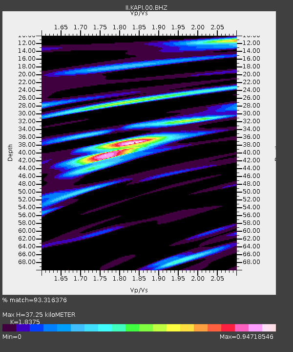
| Estimated Moho Depth: |
37.25 km |
| Estimated Crust Vp/Vs: |
1.84 |
| Assumed Crust Vp: |
6.343 km/s |
| Estimated Crust Vs: |
3.452 km/s |
| Estimated Crust Poisson's Ratio: |
0.29 |
|
| Radial Match: |
93.316376 % |
| Radial Bump: |
400 |
| Transverse Match: |
88.6949 % |
| Transverse Bump: |
400 |
| SOD ConfigId: |
558545 |
| Insert Time: |
2013-09-19 05:54:15.980 +0000 |
| GWidth: |
2.5 |
| Max Bumps: |
400 |
| Tol: |
0.001 |
|
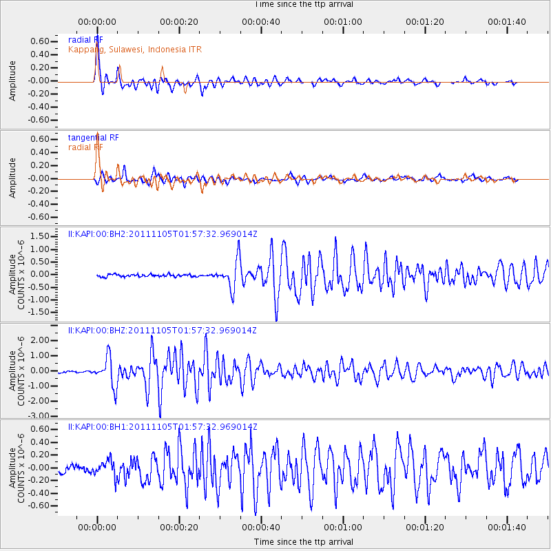
Signal To Noise
| Channel | StoN | STA | LTA |
| II:KAPI:00:BHZ:20111105T01:57:32.969014Z | 14.471284 | 9.846198E-7 | 6.8039554E-8 |
| II:KAPI:00:BH1:20111105T01:57:32.969014Z | 2.577286 | 1.2860176E-7 | 4.9898127E-8 |
| II:KAPI:00:BH2:20111105T01:57:32.969014Z | 13.172539 | 6.0057135E-7 | 4.5592685E-8 |
| Arrivals |
| Ps | 5.2 SECOND |
| PpPs | 16 SECOND |
| PsPs/PpSs | 21 SECOND |


