You are here: Home > Network List > CN - Canadian National Seismograph Network Stations List
> Station INK INUVIK, NT, CANADA.ANADA > Earthquake Result Viewer
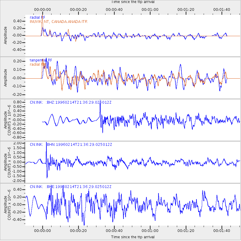
INK INUVIK, NT, CANADA.ANADA - Earthquake Result Viewer
*The percent match for this event was below the threshold and hence no stack was calculated.
| Earthquake location: |
Southeast Of Honshu, Japan |
| Earthquake latitude/longitude: |
29.2/140.4 |
| Earthquake time(UTC): |
1996/02/14 (045) 21:26:56 GMT |
| Earthquake Depth: |
142 km |
| Earthquake Magnitude: |
5.9 MB |
| Earthquake Catalog/Contributor: |
WHDF/NEIC |
|
| Network: |
CN Canadian National Seismograph Network |
| Station: |
INK INUVIK, NT, CANADA.ANADA |
| Lat/Lon: |
68.31 N/133.52 W |
| Elevation: |
40 m |
|
| Distance: |
61.8 deg |
| Az: |
24.897 deg |
| Baz: |
278.178 deg |
| Ray Param: |
$rayparam |
*The percent match for this event was below the threshold and hence was not used in the summary stack. |
|
| Radial Match: |
58.321526 % |
| Radial Bump: |
400 |
| Transverse Match: |
76.841286 % |
| Transverse Bump: |
400 |
| SOD ConfigId: |
4480 |
| Insert Time: |
2010-02-27 06:32:17.630 +0000 |
| GWidth: |
2.5 |
| Max Bumps: |
400 |
| Tol: |
0.001 |
|
Signal To Noise
| Channel | StoN | STA | LTA |
| CN:INK: :BHN:19960214T21:36:29.025012Z | 3.5402894 | 6.2989716E-7 | 1.779225E-7 |
| CN:INK: :BHE:19960214T21:36:29.025012Z | 1.2199117 | 1.9079533E-7 | 1.5640094E-7 |
| CN:INK: :BHZ:19960214T21:36:29.025012Z | 2.12315 | 2.4809069E-7 | 1.1685028E-7 |
| Arrivals |
| Ps | |
| PpPs | |
| PsPs/PpSs | |


