You are here: Home > Network List > US - United States National Seismic Network Stations List
> Station EGMT Eagleton, Montana, USA > Earthquake Result Viewer
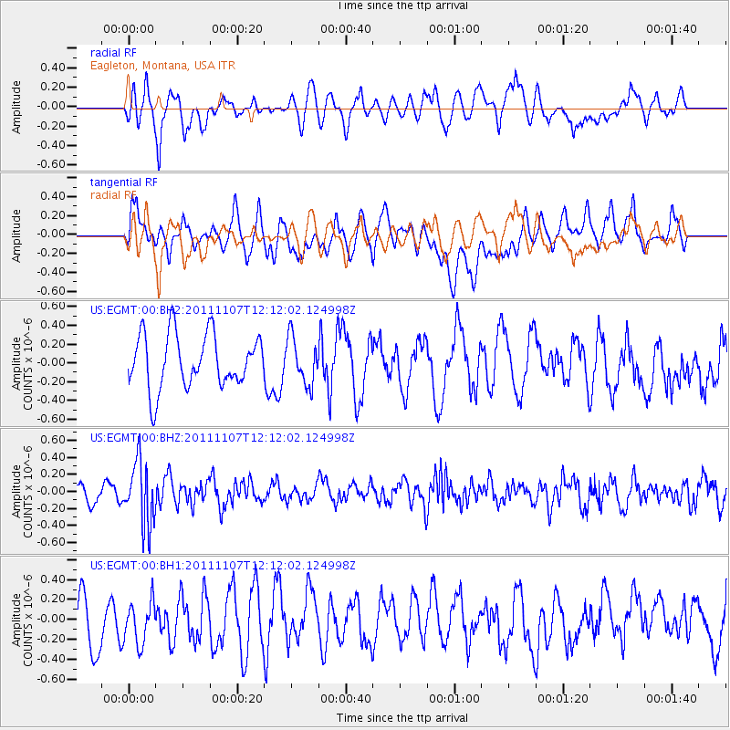
EGMT Eagleton, Montana, USA - Earthquake Result Viewer
*The percent match for this event was below the threshold and hence no stack was calculated.
| Earthquake location: |
Afghanistan-Tajikistan Bord Reg. |
| Earthquake latitude/longitude: |
36.5/71.1 |
| Earthquake time(UTC): |
2011/11/07 (311) 11:59:31 GMT |
| Earthquake Depth: |
212 km |
| Earthquake Magnitude: |
5.7 MB, 5.6 MW, 5.7 MW |
| Earthquake Catalog/Contributor: |
WHDF/NEIC |
|
| Network: |
US United States National Seismic Network |
| Station: |
EGMT Eagleton, Montana, USA |
| Lat/Lon: |
48.02 N/109.75 W |
| Elevation: |
1055 m |
|
| Distance: |
95.8 deg |
| Az: |
0.578 deg |
| Baz: |
359.306 deg |
| Ray Param: |
$rayparam |
*The percent match for this event was below the threshold and hence was not used in the summary stack. |
|
| Radial Match: |
52.38537 % |
| Radial Bump: |
400 |
| Transverse Match: |
57.7477 % |
| Transverse Bump: |
400 |
| SOD ConfigId: |
558545 |
| Insert Time: |
2013-09-19 06:04:34.609 +0000 |
| GWidth: |
2.5 |
| Max Bumps: |
400 |
| Tol: |
0.001 |
|
Signal To Noise
| Channel | StoN | STA | LTA |
| US:EGMT:00:BHZ:20111107T12:12:02.124998Z | 3.3466465 | 3.7264442E-7 | 1.1134861E-7 |
| US:EGMT:00:BH1:20111107T12:12:02.124998Z | 0.8072333 | 2.3667867E-7 | 2.9319736E-7 |
| US:EGMT:00:BH2:20111107T12:12:02.124998Z | 0.8783905 | 2.5038136E-7 | 2.8504562E-7 |
| Arrivals |
| Ps | |
| PpPs | |
| PsPs/PpSs | |


