You are here: Home > Network List > US - United States National Seismic Network Stations List
> Station DGMT Dagmar, Montana, USA > Earthquake Result Viewer
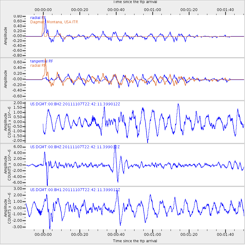
DGMT Dagmar, Montana, USA - Earthquake Result Viewer
*The percent match for this event was below the threshold and hence no stack was calculated.
| Earthquake location: |
Nicaragua |
| Earthquake latitude/longitude: |
11.6/-85.9 |
| Earthquake time(UTC): |
2011/11/07 (311) 22:35:25 GMT |
| Earthquake Depth: |
177 km |
| Earthquake Magnitude: |
6.0 MB, 6.0 MW, 6.1 MW |
| Earthquake Catalog/Contributor: |
WHDF/NEIC |
|
| Network: |
US United States National Seismic Network |
| Station: |
DGMT Dagmar, Montana, USA |
| Lat/Lon: |
48.47 N/104.20 W |
| Elevation: |
0.0 m |
|
| Distance: |
39.9 deg |
| Az: |
340.933 deg |
| Baz: |
151.247 deg |
| Ray Param: |
$rayparam |
*The percent match for this event was below the threshold and hence was not used in the summary stack. |
|
| Radial Match: |
72.457306 % |
| Radial Bump: |
325 |
| Transverse Match: |
66.16532 % |
| Transverse Bump: |
374 |
| SOD ConfigId: |
558545 |
| Insert Time: |
2013-09-19 06:07:58.263 +0000 |
| GWidth: |
2.5 |
| Max Bumps: |
400 |
| Tol: |
0.001 |
|
Signal To Noise
| Channel | StoN | STA | LTA |
| US:DGMT:00:BHZ:20111107T22:42:11.399012Z | 10.821418 | 2.4126998E-6 | 2.2295599E-7 |
| US:DGMT:00:BH1:20111107T22:42:11.399012Z | 2.7860487 | 1.3886782E-6 | 4.9844004E-7 |
| US:DGMT:00:BH2:20111107T22:42:11.399012Z | 1.2315556 | 7.1231807E-7 | 5.783889E-7 |
| Arrivals |
| Ps | |
| PpPs | |
| PsPs/PpSs | |


