You are here: Home > Network List > CN - Canadian National Seismograph Network Stations List
> Station LLLB LILLOOET, BC, CANADA ADA > Earthquake Result Viewer
LLLB LILLOOET, BC, CANADA ADA - Earthquake Result Viewer
| Earthquake location: |
Vanuatu Islands |
| Earthquake latitude/longitude: |
-15.6/167.7 |
| Earthquake time(UTC): |
2007/08/01 (213) 17:08:51 GMT |
| Earthquake Depth: |
120 km |
| Earthquake Magnitude: |
6.2 MB, 7.2 MW, 7.2 MW |
| Earthquake Catalog/Contributor: |
WHDF/NEIC |
|
| Network: |
CN Canadian National Seismograph Network |
| Station: |
LLLB LILLOOET, BC, CANADA ADA |
| Lat/Lon: |
50.61 N/121.88 W |
| Elevation: |
700 m |
|
| Distance: |
90.0 deg |
| Az: |
36.897 deg |
| Baz: |
245.235 deg |
| Ray Param: |
0.041678976 |
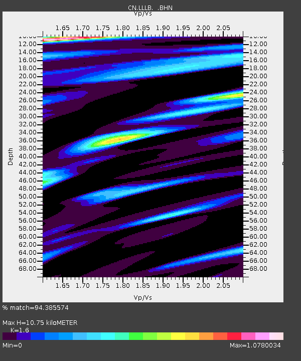
| Estimated Moho Depth: |
10.75 km |
| Estimated Crust Vp/Vs: |
1.60 |
| Assumed Crust Vp: |
6.597 km/s |
| Estimated Crust Vs: |
4.123 km/s |
| Estimated Crust Poisson's Ratio: |
0.18 |
|
| Radial Match: |
94.385574 % |
| Radial Bump: |
400 |
| Transverse Match: |
83.450226 % |
| Transverse Bump: |
400 |
| SOD ConfigId: |
2564 |
| Insert Time: |
2010-02-27 06:32:29.569 +0000 |
| GWidth: |
2.5 |
| Max Bumps: |
400 |
| Tol: |
0.001 |
|
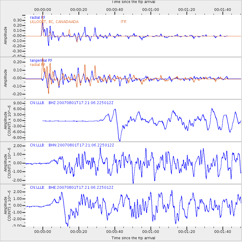
Signal To Noise
| Channel | StoN | STA | LTA |
| CN:LLLB: :BHN:20070801T17:21:06.225012Z | 2.9377253 | 9.841086E-8 | 3.3499E-8 |
| CN:LLLB: :BHE:20070801T17:21:06.225012Z | 3.1331468 | 1.5602133E-7 | 4.9797006E-8 |
| CN:LLLB: :BHZ:20070801T17:21:06.225012Z | 12.065902 | 7.209375E-7 | 5.9749986E-8 |
| Arrivals |
| Ps | 1.0 SECOND |
| PpPs | 4.1 SECOND |
| PsPs/PpSs | 5.1 SECOND |


