You are here: Home > Network List > US - United States National Seismic Network Stations List
> Station AGMN Agassiz National Wildlife Refuge, Minnesota, USA > Earthquake Result Viewer
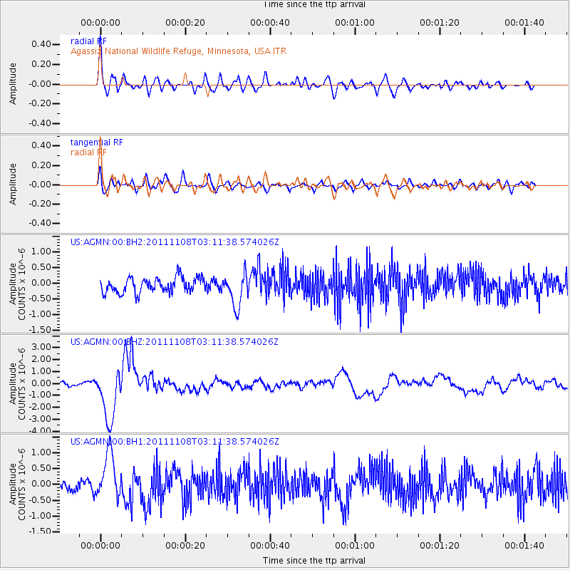
AGMN Agassiz National Wildlife Refuge, Minnesota, USA - Earthquake Result Viewer
*The percent match for this event was below the threshold and hence no stack was calculated.
| Earthquake location: |
Northeast Of Taiwan |
| Earthquake latitude/longitude: |
27.3/125.6 |
| Earthquake time(UTC): |
2011/11/08 (312) 02:59:08 GMT |
| Earthquake Depth: |
225 km |
| Earthquake Magnitude: |
6.5 MB, 6.9 MW, 6.9 MW |
| Earthquake Catalog/Contributor: |
WHDF/NEIC |
|
| Network: |
US United States National Seismic Network |
| Station: |
AGMN Agassiz National Wildlife Refuge, Minnesota, USA |
| Lat/Lon: |
48.30 N/95.86 W |
| Elevation: |
351 m |
|
| Distance: |
96.0 deg |
| Az: |
26.409 deg |
| Baz: |
323.658 deg |
| Ray Param: |
$rayparam |
*The percent match for this event was below the threshold and hence was not used in the summary stack. |
|
| Radial Match: |
79.45059 % |
| Radial Bump: |
400 |
| Transverse Match: |
59.120167 % |
| Transverse Bump: |
400 |
| SOD ConfigId: |
558545 |
| Insert Time: |
2013-09-19 06:11:38.146 +0000 |
| GWidth: |
2.5 |
| Max Bumps: |
400 |
| Tol: |
0.001 |
|
Signal To Noise
| Channel | StoN | STA | LTA |
| US:AGMN:00:BHZ:20111108T03:11:38.574026Z | 8.622943 | 2.2188128E-6 | 2.5731504E-7 |
| US:AGMN:00:BH1:20111108T03:11:38.574026Z | 3.6510596 | 7.3851527E-7 | 2.0227422E-7 |
| US:AGMN:00:BH2:20111108T03:11:38.574026Z | 2.2725928 | 5.3661114E-7 | 2.3612287E-7 |
| Arrivals |
| Ps | |
| PpPs | |
| PsPs/PpSs | |


