You are here: Home > Network List > PF - Volcanologic Network of Piton de Fournaise-OVPF Stations List
> Station HIM cratere Himiltrude > Earthquake Result Viewer
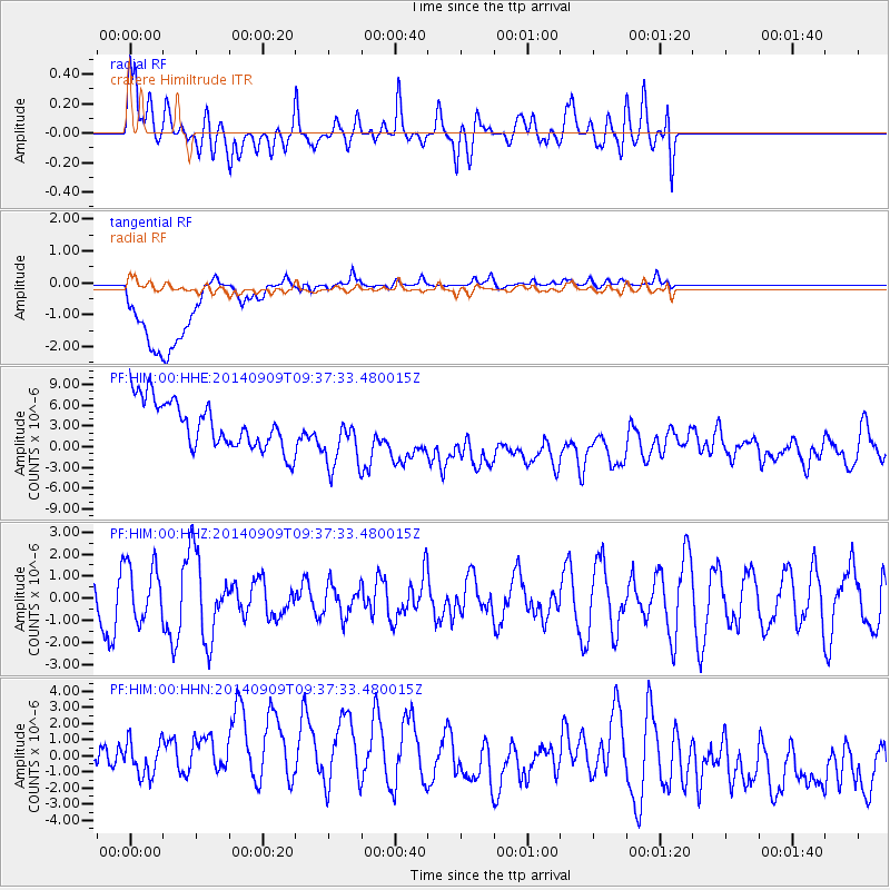
HIM cratere Himiltrude - Earthquake Result Viewer
*The percent match for this event was below the threshold and hence no stack was calculated.
| Earthquake location: |
Myanmar-India Border Region |
| Earthquake latitude/longitude: |
22.1/93.2 |
| Earthquake time(UTC): |
2014/09/09 (252) 09:28:22 GMT |
| Earthquake Depth: |
11 km |
| Earthquake Magnitude: |
5.4 MW |
| Earthquake Catalog/Contributor: |
ISC/ISC |
|
| Network: |
PF Volcanologic Network of Piton de Fournaise-OVPF |
| Station: |
HIM cratere Himiltrude |
| Lat/Lon: |
21.21 S/55.72 E |
| Elevation: |
1958 m |
|
| Distance: |
56.5 deg |
| Az: |
222.921 deg |
| Baz: |
42.598 deg |
| Ray Param: |
$rayparam |
*The percent match for this event was below the threshold and hence was not used in the summary stack. |
|
| Radial Match: |
54.028633 % |
| Radial Bump: |
400 |
| Transverse Match: |
36.25585 % |
| Transverse Bump: |
400 |
| SOD ConfigId: |
3390531 |
| Insert Time: |
2019-04-13 22:52:37.520 +0000 |
| GWidth: |
2.5 |
| Max Bumps: |
400 |
| Tol: |
0.001 |
|
Signal To Noise
| Channel | StoN | STA | LTA |
| PF:HIM:00:HHZ:20140909T09:37:33.480015Z | 0.73261905 | 1.2710458E-6 | 1.7349342E-6 |
| PF:HIM:00:HHN:20140909T09:37:33.480015Z | 0.93975735 | 3.047884E-6 | 3.243267E-6 |
| PF:HIM:00:HHE:20140909T09:37:33.480015Z | 1.2833171 | 4.355883E-6 | 3.3942374E-6 |
| Arrivals |
| Ps | |
| PpPs | |
| PsPs/PpSs | |


