You are here: Home > Network List > II - Global Seismograph Network (GSN - IRIS/IDA) Stations List
> Station KAPI Kappang, Sulawesi, Indonesia > Earthquake Result Viewer
KAPI Kappang, Sulawesi, Indonesia - Earthquake Result Viewer
| Earthquake location: |
Turkey |
| Earthquake latitude/longitude: |
38.4/43.2 |
| Earthquake time(UTC): |
2011/11/09 (313) 19:23:33 GMT |
| Earthquake Depth: |
5.0 km |
| Earthquake Magnitude: |
5.6 MB, 5.6 MS, 5.6 MW, 5.6 MW |
| Earthquake Catalog/Contributor: |
WHDF/NEIC |
|
| Network: |
II Global Seismograph Network (GSN - IRIS/IDA) |
| Station: |
KAPI Kappang, Sulawesi, Indonesia |
| Lat/Lon: |
5.01 S/119.75 E |
| Elevation: |
300 m |
|
| Distance: |
82.6 deg |
| Az: |
102.338 deg |
| Baz: |
309.63 deg |
| Ray Param: |
0.046776406 |
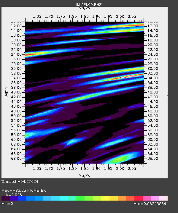
| Estimated Moho Depth: |
33.25 km |
| Estimated Crust Vp/Vs: |
2.03 |
| Assumed Crust Vp: |
6.343 km/s |
| Estimated Crust Vs: |
3.132 km/s |
| Estimated Crust Poisson's Ratio: |
0.34 |
|
| Radial Match: |
94.27624 % |
| Radial Bump: |
400 |
| Transverse Match: |
92.17965 % |
| Transverse Bump: |
400 |
| SOD ConfigId: |
558545 |
| Insert Time: |
2013-09-19 06:16:11.441 +0000 |
| GWidth: |
2.5 |
| Max Bumps: |
400 |
| Tol: |
0.001 |
|

Signal To Noise
| Channel | StoN | STA | LTA |
| II:KAPI:00:BHZ:20111109T19:35:25.919016Z | 14.941683 | 1.3160786E-6 | 8.808102E-8 |
| II:KAPI:00:BH1:20111109T19:35:25.919016Z | 5.8465457 | 2.6938025E-7 | 4.607511E-8 |
| II:KAPI:00:BH2:20111109T19:35:25.919016Z | 6.28581 | 3.3622277E-7 | 5.3489174E-8 |
| Arrivals |
| Ps | 5.5 SECOND |
| PpPs | 16 SECOND |
| PsPs/PpSs | 21 SECOND |


