You are here: Home > Network List > IU - Global Seismograph Network (GSN - IRIS/USGS) Stations List
> Station JOHN Johnston Island, USA > Earthquake Result Viewer
JOHN Johnston Island, USA - Earthquake Result Viewer
*The percent match for this event was below the threshold and hence no stack was calculated.
| Earthquake location: |
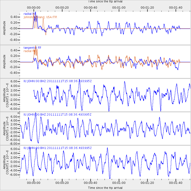
Tonga Islands |
| Earthquake latitude/longitude: |
-17.7/-173.1 |
| Earthquake time(UTC): |
2011/11/11 (315) 15:02:19 GMT |
| Earthquake Depth: |
10 km |
| Earthquake Magnitude: |
5.5 MB, 5.6 MW |
| Earthquake Catalog/Contributor: |
NEIC PDE/NEIC PDE-M |
|
| Network: |
IU Global Seismograph Network (GSN - IRIS/USGS) |
| Station: |
JOHN Johnston Island, USA |
| Lat/Lon: |
16.73 N/169.53 W |
| Elevation: |
2.0 m |
|
| Distance: |
34.4 deg |
| Az: |
6.054 deg |
| Baz: |
186.023 deg |
| Ray Param: |
$rayparam |
*The percent match for this event was below the threshold and hence was not used in the summary stack. |
|
| Radial Match: |
60.904602 % |
| Radial Bump: |
400 |
| Transverse Match: |
47.642723 % |
| Transverse Bump: |
400 |
| SOD ConfigId: |
558545 |
| Insert Time: |
2013-09-19 06:23:49.397 +0000 |
| GWidth: |
2.5 |
| Max Bumps: |
400 |
| Tol: |
0.001 |
|
Signal To Noise
| Channel | StoN | STA | LTA |
| IU:JOHN:00:BHZ:20111111T15:08:36.493995Z | 1.768332 | 4.7205303E-6 | 2.669482E-6 |
| IU:JOHN:00:BH1:20111111T15:08:36.493995Z | 1.358843 | 3.8116048E-6 | 2.805037E-6 |
| IU:JOHN:00:BH2:20111111T15:08:36.493995Z | 2.020143 | 4.179649E-6 | 2.0689868E-6 |
| Arrivals |
| Ps | |
| PpPs | |
| PsPs/PpSs | |


