You are here: Home > Network List > IU - Global Seismograph Network (GSN - IRIS/USGS) Stations List
> Station PMG Port Moresby, New Guinea > Earthquake Result Viewer
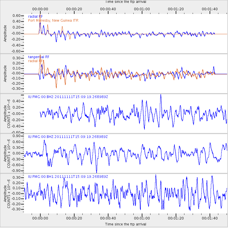
PMG Port Moresby, New Guinea - Earthquake Result Viewer
*The percent match for this event was below the threshold and hence no stack was calculated.
| Earthquake location: |
Tonga Islands |
| Earthquake latitude/longitude: |
-17.7/-173.1 |
| Earthquake time(UTC): |
2011/11/11 (315) 15:02:19 GMT |
| Earthquake Depth: |
10 km |
| Earthquake Magnitude: |
5.5 MB, 5.6 MW |
| Earthquake Catalog/Contributor: |
NEIC PDE/NEIC PDE-M |
|
| Network: |
IU Global Seismograph Network (GSN - IRIS/USGS) |
| Station: |
PMG Port Moresby, New Guinea |
| Lat/Lon: |
9.40 S/147.16 E |
| Elevation: |
90 m |
|
| Distance: |
39.4 deg |
| Az: |
276.745 deg |
| Baz: |
106.396 deg |
| Ray Param: |
$rayparam |
*The percent match for this event was below the threshold and hence was not used in the summary stack. |
|
| Radial Match: |
73.48011 % |
| Radial Bump: |
400 |
| Transverse Match: |
60.870365 % |
| Transverse Bump: |
400 |
| SOD ConfigId: |
558545 |
| Insert Time: |
2013-09-19 06:24:08.729 +0000 |
| GWidth: |
2.5 |
| Max Bumps: |
400 |
| Tol: |
0.001 |
|
Signal To Noise
| Channel | StoN | STA | LTA |
| IU:PMG:00:BHZ:20111111T15:09:19.268989Z | 3.817074 | 3.356851E-7 | 8.7943036E-8 |
| IU:PMG:00:BH1:20111111T15:09:19.268989Z | 1.1301705 | 1.06680204E-7 | 9.4393016E-8 |
| IU:PMG:00:BH2:20111111T15:09:19.268989Z | 1.5621128 | 1.6835946E-7 | 1.0777677E-7 |
| Arrivals |
| Ps | |
| PpPs | |
| PsPs/PpSs | |


