You are here: Home > Network List > G - GEOSCOPE Stations List
> Station KIP Kipapa - Hawaii, USA > Earthquake Result Viewer
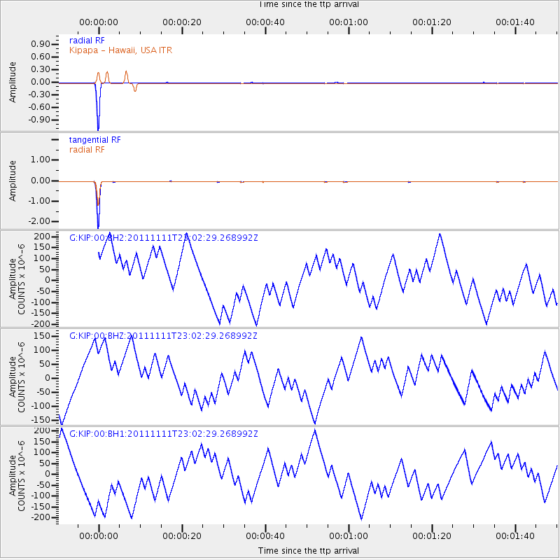
KIP Kipapa - Hawaii, USA - Earthquake Result Viewer
*The percent match for this event was below the threshold and hence no stack was calculated.
| Earthquake location: |
Southern East Pacific Rise |
| Earthquake latitude/longitude: |
-55.7/-124.3 |
| Earthquake time(UTC): |
2011/11/11 (315) 22:50:40 GMT |
| Earthquake Depth: |
10 km |
| Earthquake Magnitude: |
5.6 MW |
| Earthquake Catalog/Contributor: |
NEIC PDE/NEIC PDE-M |
|
| Network: |
G GEOSCOPE |
| Station: |
KIP Kipapa - Hawaii, USA |
| Lat/Lon: |
21.42 N/158.01 W |
| Elevation: |
70 m |
|
| Distance: |
82.0 deg |
| Az: |
328.54 deg |
| Baz: |
161.516 deg |
| Ray Param: |
$rayparam |
*The percent match for this event was below the threshold and hence was not used in the summary stack. |
|
| Radial Match: |
99.71625 % |
| Radial Bump: |
33 |
| Transverse Match: |
99.74507 % |
| Transverse Bump: |
31 |
| SOD ConfigId: |
558545 |
| Insert Time: |
2013-09-19 06:25:53.292 +0000 |
| GWidth: |
2.5 |
| Max Bumps: |
400 |
| Tol: |
0.001 |
|
Signal To Noise
| Channel | StoN | STA | LTA |
| G:KIP:00:BHZ:20111111T23:02:29.268992Z | 3.7778714 | 1.6885041E-4 | 4.4694592E-5 |
| G:KIP:00:BH1:20111111T23:02:29.268992Z | 3.7401547 | 2.2073464E-4 | 5.9017515E-5 |
| G:KIP:00:BH2:20111111T23:02:29.268992Z | 3.7516773 | 2.2156807E-4 | 5.9058406E-5 |
| Arrivals |
| Ps | |
| PpPs | |
| PsPs/PpSs | |


