You are here: Home > Network List > II - Global Seismograph Network (GSN - IRIS/IDA) Stations List
> Station ABPO Ambohimpanompo, Madagascar > Earthquake Result Viewer
ABPO Ambohimpanompo, Madagascar - Earthquake Result Viewer
| Earthquake location: |
Southern Molucca Sea |
| Earthquake latitude/longitude: |
-0.9/126.9 |
| Earthquake time(UTC): |
2011/11/14 (318) 04:05:11 GMT |
| Earthquake Depth: |
17 km |
| Earthquake Magnitude: |
6.2 MB, 6.2 MS, 6.3 MW, 6.3 MW |
| Earthquake Catalog/Contributor: |
WHDF/NEIC |
|
| Network: |
II Global Seismograph Network (GSN - IRIS/IDA) |
| Station: |
ABPO Ambohimpanompo, Madagascar |
| Lat/Lon: |
19.02 S/47.23 E |
| Elevation: |
1528 m |
|
| Distance: |
79.9 deg |
| Az: |
250.968 deg |
| Baz: |
87.529 deg |
| Ray Param: |
0.04860813 |
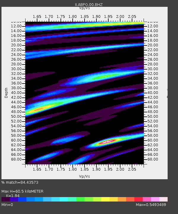
| Estimated Moho Depth: |
60.5 km |
| Estimated Crust Vp/Vs: |
1.94 |
| Assumed Crust Vp: |
6.642 km/s |
| Estimated Crust Vs: |
3.424 km/s |
| Estimated Crust Poisson's Ratio: |
0.32 |
|
| Radial Match: |
84.43573 % |
| Radial Bump: |
400 |
| Transverse Match: |
53.75937 % |
| Transverse Bump: |
400 |
| SOD ConfigId: |
558545 |
| Insert Time: |
2013-09-19 06:27:38.521 +0000 |
| GWidth: |
2.5 |
| Max Bumps: |
400 |
| Tol: |
0.001 |
|
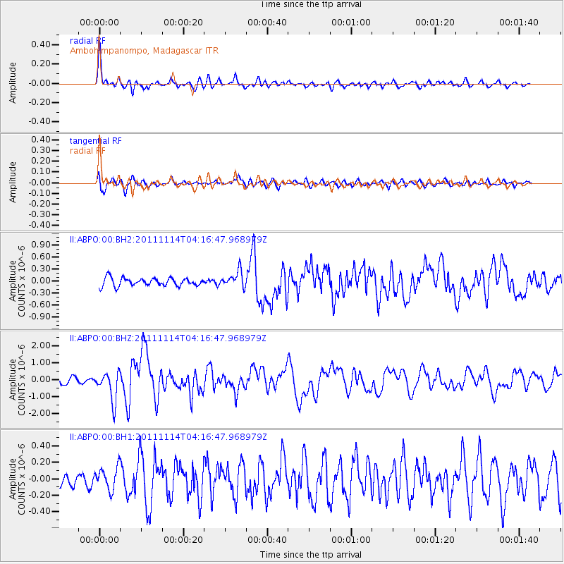
Signal To Noise
| Channel | StoN | STA | LTA |
| II:ABPO:00:BHZ:20111114T04:16:47.968979Z | 3.6843355 | 8.891428E-7 | 2.4133058E-7 |
| II:ABPO:00:BH1:20111114T04:16:47.968979Z | 0.9085123 | 1.4358919E-7 | 1.580487E-7 |
| II:ABPO:00:BH2:20111114T04:16:47.968979Z | 2.04831 | 2.0475919E-7 | 9.996494E-8 |
| Arrivals |
| Ps | 8.8 SECOND |
| PpPs | 26 SECOND |
| PsPs/PpSs | 35 SECOND |


