You are here: Home > Network List > II - Global Seismograph Network (GSN - IRIS/IDA) Stations List
> Station PALK Pallekele, Sri Lanka > Earthquake Result Viewer
PALK Pallekele, Sri Lanka - Earthquake Result Viewer
| Earthquake location: |
Southern Molucca Sea |
| Earthquake latitude/longitude: |
-0.9/126.9 |
| Earthquake time(UTC): |
2011/11/14 (318) 04:05:11 GMT |
| Earthquake Depth: |
17 km |
| Earthquake Magnitude: |
6.2 MB, 6.2 MS, 6.3 MW, 6.3 MW |
| Earthquake Catalog/Contributor: |
WHDF/NEIC |
|
| Network: |
II Global Seismograph Network (GSN - IRIS/IDA) |
| Station: |
PALK Pallekele, Sri Lanka |
| Lat/Lon: |
7.27 N/80.70 E |
| Elevation: |
460 m |
|
| Distance: |
46.8 deg |
| Az: |
280.833 deg |
| Baz: |
98.148 deg |
| Ray Param: |
0.070387706 |
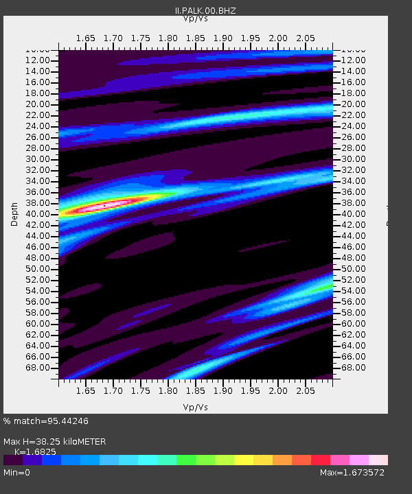
| Estimated Moho Depth: |
38.25 km |
| Estimated Crust Vp/Vs: |
1.68 |
| Assumed Crust Vp: |
6.545 km/s |
| Estimated Crust Vs: |
3.89 km/s |
| Estimated Crust Poisson's Ratio: |
0.23 |
|
| Radial Match: |
95.44246 % |
| Radial Bump: |
400 |
| Transverse Match: |
85.823204 % |
| Transverse Bump: |
400 |
| SOD ConfigId: |
558545 |
| Insert Time: |
2013-09-19 06:27:49.526 +0000 |
| GWidth: |
2.5 |
| Max Bumps: |
400 |
| Tol: |
0.001 |
|
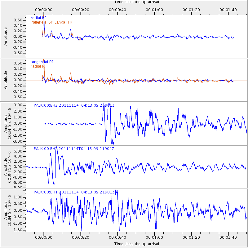
Signal To Noise
| Channel | StoN | STA | LTA |
| II:PALK:00:BHZ:20111114T04:13:09.21901Z | 24.099672 | 2.6751527E-6 | 1.110037E-7 |
| II:PALK:00:BH1:20111114T04:13:09.21901Z | 4.9049506 | 4.3450962E-7 | 8.858593E-8 |
| II:PALK:00:BH2:20111114T04:13:09.21901Z | 19.866442 | 1.5183041E-6 | 7.6425565E-8 |
| Arrivals |
| Ps | 4.3 SECOND |
| PpPs | 15 SECOND |
| PsPs/PpSs | 19 SECOND |


