You are here: Home > Network List > IU - Global Seismograph Network (GSN - IRIS/USGS) Stations List
> Station HNR Honiara, Solomon Islands > Earthquake Result Viewer
HNR Honiara, Solomon Islands - Earthquake Result Viewer
| Earthquake location: |
Southern Molucca Sea |
| Earthquake latitude/longitude: |
-0.9/126.9 |
| Earthquake time(UTC): |
2011/11/14 (318) 04:05:11 GMT |
| Earthquake Depth: |
17 km |
| Earthquake Magnitude: |
6.2 MB, 6.2 MS, 6.3 MW, 6.3 MW |
| Earthquake Catalog/Contributor: |
WHDF/NEIC |
|
| Network: |
IU Global Seismograph Network (GSN - IRIS/USGS) |
| Station: |
HNR Honiara, Solomon Islands |
| Lat/Lon: |
9.44 S/159.95 E |
| Elevation: |
100 m |
|
| Distance: |
33.9 deg |
| Az: |
105.512 deg |
| Baz: |
282.448 deg |
| Ray Param: |
0.07796441 |
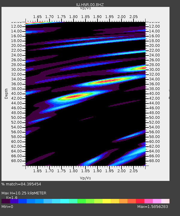
| Estimated Moho Depth: |
10.25 km |
| Estimated Crust Vp/Vs: |
1.60 |
| Assumed Crust Vp: |
6.183 km/s |
| Estimated Crust Vs: |
3.864 km/s |
| Estimated Crust Poisson's Ratio: |
0.18 |
|
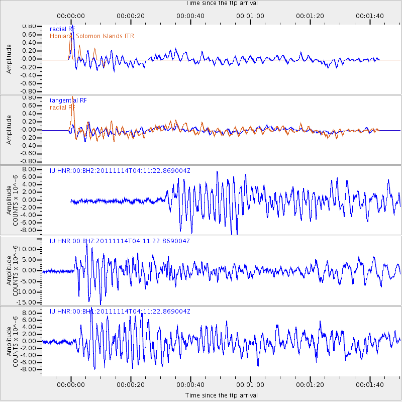
| Radial Match: |
84.395454 % |
| Radial Bump: |
400 |
| Transverse Match: |
71.289024 % |
| Transverse Bump: |
400 |
| SOD ConfigId: |
558545 |
| Insert Time: |
2013-09-19 06:28:05.331 +0000 |
| GWidth: |
2.5 |
| Max Bumps: |
400 |
| Tol: |
0.001 |
|
Signal To Noise
| Channel | StoN | STA | LTA |
| IU:HNR:00:BHZ:20111114T04:11:22.869004Z | 12.023041 | 3.4402533E-6 | 2.8613837E-7 |
| IU:HNR:00:BH1:20111114T04:11:22.869004Z | 5.3367977 | 1.8751865E-6 | 3.5136924E-7 |
| IU:HNR:00:BH2:20111114T04:11:22.869004Z | 5.847654 | 1.5878901E-6 | 2.7154312E-7 |
| Arrivals |
| Ps | 1.1 SECOND |
| PpPs | 4.0 SECOND |
| PsPs/PpSs | 5.1 SECOND |


