You are here: Home > Network List > IU - Global Seismograph Network (GSN - IRIS/USGS) Stations List
> Station GNI Garni, Armenia > Earthquake Result Viewer
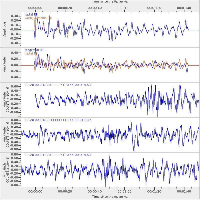
GNI Garni, Armenia - Earthquake Result Viewer
*The percent match for this event was below the threshold and hence no stack was calculated.
| Earthquake location: |
Minahassa Peninsula, Sulawesi |
| Earthquake latitude/longitude: |
-0.1/121.9 |
| Earthquake time(UTC): |
2011/11/15 (319) 10:43:51 GMT |
| Earthquake Depth: |
276 km |
| Earthquake Magnitude: |
5.7 MB, 5.7 MW, 5.8 MW |
| Earthquake Catalog/Contributor: |
WHDF/NEIC |
|
| Network: |
IU Global Seismograph Network (GSN - IRIS/USGS) |
| Station: |
GNI Garni, Armenia |
| Lat/Lon: |
40.15 N/44.74 E |
| Elevation: |
1609 m |
|
| Distance: |
80.3 deg |
| Az: |
310.685 deg |
| Baz: |
98.392 deg |
| Ray Param: |
$rayparam |
*The percent match for this event was below the threshold and hence was not used in the summary stack. |
|
| Radial Match: |
62.092342 % |
| Radial Bump: |
400 |
| Transverse Match: |
57.60832 % |
| Transverse Bump: |
400 |
| SOD ConfigId: |
558545 |
| Insert Time: |
2013-09-19 06:31:13.970 +0000 |
| GWidth: |
2.5 |
| Max Bumps: |
400 |
| Tol: |
0.001 |
|
Signal To Noise
| Channel | StoN | STA | LTA |
| IU:GNI:00:BHZ:20111115T10:55:00.91897Z | 2.371846 | 2.836391E-7 | 1.195858E-7 |
| IU:GNI:00:BH1:20111115T10:55:00.91897Z | 1.3823928 | 1.7044111E-7 | 1.2329427E-7 |
| IU:GNI:00:BH2:20111115T10:55:00.91897Z | 1.269521 | 1.8591173E-7 | 1.4644243E-7 |
| Arrivals |
| Ps | |
| PpPs | |
| PsPs/PpSs | |


