You are here: Home > Network List > IU - Global Seismograph Network (GSN - IRIS/USGS) Stations List
> Station SNZO South Karori, New Zealand > Earthquake Result Viewer
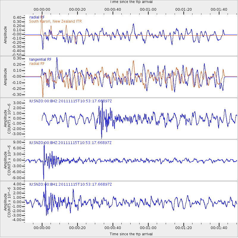
SNZO South Karori, New Zealand - Earthquake Result Viewer
*The percent match for this event was below the threshold and hence no stack was calculated.
| Earthquake location: |
Minahassa Peninsula, Sulawesi |
| Earthquake latitude/longitude: |
-0.1/121.9 |
| Earthquake time(UTC): |
2011/11/15 (319) 10:43:51 GMT |
| Earthquake Depth: |
276 km |
| Earthquake Magnitude: |
5.7 MB, 5.7 MW, 5.8 MW |
| Earthquake Catalog/Contributor: |
WHDF/NEIC |
|
| Network: |
IU Global Seismograph Network (GSN - IRIS/USGS) |
| Station: |
SNZO South Karori, New Zealand |
| Lat/Lon: |
41.31 S/174.70 E |
| Elevation: |
120 m |
|
| Distance: |
62.8 deg |
| Az: |
137.591 deg |
| Baz: |
296.463 deg |
| Ray Param: |
$rayparam |
*The percent match for this event was below the threshold and hence was not used in the summary stack. |
|
| Radial Match: |
48.455185 % |
| Radial Bump: |
400 |
| Transverse Match: |
48.539806 % |
| Transverse Bump: |
400 |
| SOD ConfigId: |
558545 |
| Insert Time: |
2013-09-19 06:31:43.260 +0000 |
| GWidth: |
2.5 |
| Max Bumps: |
400 |
| Tol: |
0.001 |
|
Signal To Noise
| Channel | StoN | STA | LTA |
| IU:SNZO:00:BHZ:20111115T10:53:17.66897Z | 7.4314303 | 2.8947115E-6 | 3.895228E-7 |
| IU:SNZO:00:BH1:20111115T10:53:17.66897Z | 2.4713464 | 1.5058455E-6 | 6.093219E-7 |
| IU:SNZO:00:BH2:20111115T10:53:17.66897Z | 2.176203 | 1.445788E-6 | 6.6436263E-7 |
| Arrivals |
| Ps | |
| PpPs | |
| PsPs/PpSs | |


