You are here: Home > Network List > US - United States National Seismic Network Stations List
> Station HDIL Hopedale, Illinois, USA > Earthquake Result Viewer
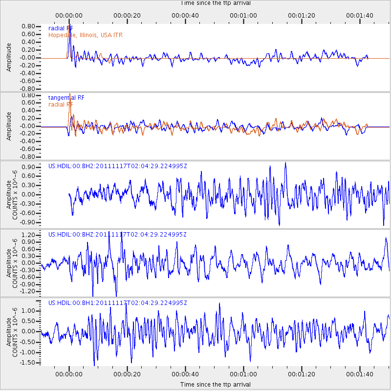
HDIL Hopedale, Illinois, USA - Earthquake Result Viewer
*The percent match for this event was below the threshold and hence no stack was calculated.
| Earthquake location: |
Off Coast Of Ecuador |
| Earthquake latitude/longitude: |
-1.7/-81.5 |
| Earthquake time(UTC): |
2011/11/17 (321) 01:57:05 GMT |
| Earthquake Depth: |
27 km |
| Earthquake Magnitude: |
5.7 MB, 5.6 MS, 6.0 MW, 5.9 MW |
| Earthquake Catalog/Contributor: |
WHDF/NEIC |
|
| Network: |
US United States National Seismic Network |
| Station: |
HDIL Hopedale, Illinois, USA |
| Lat/Lon: |
40.56 N/89.29 W |
| Elevation: |
219 m |
|
| Distance: |
42.6 deg |
| Az: |
351.279 deg |
| Baz: |
168.527 deg |
| Ray Param: |
$rayparam |
*The percent match for this event was below the threshold and hence was not used in the summary stack. |
|
| Radial Match: |
64.55096 % |
| Radial Bump: |
400 |
| Transverse Match: |
61.658566 % |
| Transverse Bump: |
400 |
| SOD ConfigId: |
558545 |
| Insert Time: |
2013-09-19 06:39:41.050 +0000 |
| GWidth: |
2.5 |
| Max Bumps: |
400 |
| Tol: |
0.001 |
|
Signal To Noise
| Channel | StoN | STA | LTA |
| US:HDIL:00:BHZ:20111117T02:04:29.224995Z | 1.99099 | 3.0523816E-7 | 1.5330973E-7 |
| US:HDIL:00:BH1:20111117T02:04:29.224995Z | 1.1762745 | 2.876144E-7 | 2.44513E-7 |
| US:HDIL:00:BH2:20111117T02:04:29.224995Z | 1.2097164 | 2.341121E-7 | 1.9352642E-7 |
| Arrivals |
| Ps | |
| PpPs | |
| PsPs/PpSs | |


