You are here: Home > Network List > US - United States National Seismic Network Stations List
> Station OGNE Ogallala, Nebraska, USA > Earthquake Result Viewer
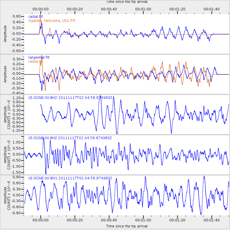
OGNE Ogallala, Nebraska, USA - Earthquake Result Viewer
*The percent match for this event was below the threshold and hence no stack was calculated.
| Earthquake location: |
Off Coast Of Ecuador |
| Earthquake latitude/longitude: |
-1.7/-81.5 |
| Earthquake time(UTC): |
2011/11/17 (321) 01:57:05 GMT |
| Earthquake Depth: |
27 km |
| Earthquake Magnitude: |
5.7 MB, 5.6 MS, 6.0 MW, 5.9 MW |
| Earthquake Catalog/Contributor: |
WHDF/NEIC |
|
| Network: |
US United States National Seismic Network |
| Station: |
OGNE Ogallala, Nebraska, USA |
| Lat/Lon: |
40.95 N/102.03 W |
| Elevation: |
0.0 m |
|
| Distance: |
46.4 deg |
| Az: |
338.512 deg |
| Baz: |
151.095 deg |
| Ray Param: |
$rayparam |
*The percent match for this event was below the threshold and hence was not used in the summary stack. |
|
| Radial Match: |
60.290535 % |
| Radial Bump: |
320 |
| Transverse Match: |
55.95462 % |
| Transverse Bump: |
344 |
| SOD ConfigId: |
558545 |
| Insert Time: |
2013-09-19 06:40:34.437 +0000 |
| GWidth: |
2.5 |
| Max Bumps: |
400 |
| Tol: |
0.001 |
|
Signal To Noise
| Channel | StoN | STA | LTA |
| US:OGNE:00:BHZ:20111117T02:04:58.874989Z | 6.3220406 | 7.240874E-7 | 1.1453381E-7 |
| US:OGNE:00:BH1:20111117T02:04:58.874989Z | 1.2396833 | 5.413242E-7 | 4.366633E-7 |
| US:OGNE:00:BH2:20111117T02:04:58.874989Z | 1.8626505 | 6.760634E-7 | 3.6295773E-7 |
| Arrivals |
| Ps | |
| PpPs | |
| PsPs/PpSs | |


