You are here: Home > Network List > US - United States National Seismic Network Stations List
> Station TPNV Topopah Spring, Nevada, USA > Earthquake Result Viewer
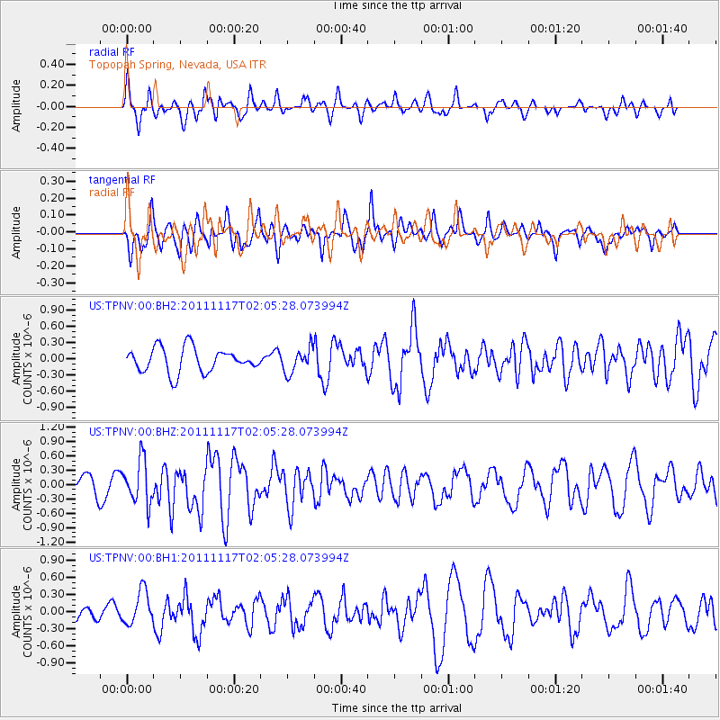
TPNV Topopah Spring, Nevada, USA - Earthquake Result Viewer
*The percent match for this event was below the threshold and hence no stack was calculated.
| Earthquake location: |
Off Coast Of Ecuador |
| Earthquake latitude/longitude: |
-1.7/-81.5 |
| Earthquake time(UTC): |
2011/11/17 (321) 01:57:05 GMT |
| Earthquake Depth: |
27 km |
| Earthquake Magnitude: |
5.7 MB, 5.6 MS, 6.0 MW, 5.9 MW |
| Earthquake Catalog/Contributor: |
WHDF/NEIC |
|
| Network: |
US United States National Seismic Network |
| Station: |
TPNV Topopah Spring, Nevada, USA |
| Lat/Lon: |
36.95 N/116.25 W |
| Elevation: |
1600 m |
|
| Distance: |
50.2 deg |
| Az: |
323.558 deg |
| Baz: |
132.17 deg |
| Ray Param: |
$rayparam |
*The percent match for this event was below the threshold and hence was not used in the summary stack. |
|
| Radial Match: |
62.222095 % |
| Radial Bump: |
400 |
| Transverse Match: |
45.175972 % |
| Transverse Bump: |
375 |
| SOD ConfigId: |
558545 |
| Insert Time: |
2013-09-19 06:40:48.127 +0000 |
| GWidth: |
2.5 |
| Max Bumps: |
400 |
| Tol: |
0.001 |
|
Signal To Noise
| Channel | StoN | STA | LTA |
| US:TPNV:00:BHZ:20111117T02:05:28.073994Z | 3.0836263 | 4.613774E-7 | 1.496217E-7 |
| US:TPNV:00:BH1:20111117T02:05:28.073994Z | 1.6104987 | 2.9795976E-7 | 1.8501086E-7 |
| US:TPNV:00:BH2:20111117T02:05:28.073994Z | 1.009004 | 2.2720043E-7 | 2.2517295E-7 |
| Arrivals |
| Ps | |
| PpPs | |
| PsPs/PpSs | |


