You are here: Home > Network List > IU - Global Seismograph Network (GSN - IRIS/USGS) Stations List
> Station HNR Honiara, Solomon Islands > Earthquake Result Viewer
HNR Honiara, Solomon Islands - Earthquake Result Viewer
*The percent match for this event was below the threshold and hence no stack was calculated.
| Earthquake location: |
Off E. Coast Of N. Island, N.Z. |
| Earthquake latitude/longitude: |
-37.8/179.4 |
| Earthquake time(UTC): |
2011/11/18 (322) 07:51:24 GMT |
| Earthquake Depth: |
12 km |
| Earthquake Magnitude: |
5.8 MB, 5.6 MS, 5.8 MW, 5.7 MW |
| Earthquake Catalog/Contributor: |
WHDF/NEIC |
|
| Network: |
IU Global Seismograph Network (GSN - IRIS/USGS) |
| Station: |
HNR Honiara, Solomon Islands |
| Lat/Lon: |
9.44 S/159.95 E |
| Elevation: |
100 m |
|
| Distance: |
33.3 deg |
| Az: |
323.148 deg |
| Baz: |
151.218 deg |
| Ray Param: |
$rayparam |
*The percent match for this event was below the threshold and hence was not used in the summary stack. |
|
| Radial Match: |
79.49287 % |
| Radial Bump: |
400 |
| Transverse Match: |
76.73278 % |
| Transverse Bump: |
376 |
| SOD ConfigId: |
558545 |
| Insert Time: |
2013-09-19 06:50:43.587 +0000 |
| GWidth: |
2.5 |
| Max Bumps: |
400 |
| Tol: |
0.001 |
|
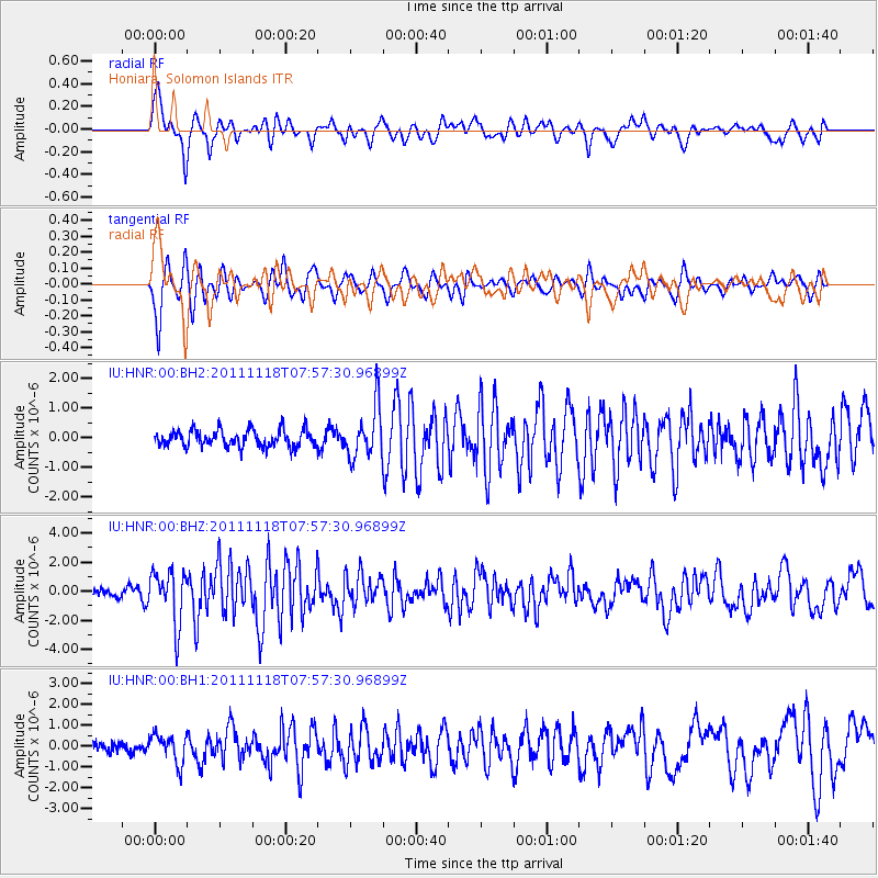
Signal To Noise
| Channel | StoN | STA | LTA |
| IU:HNR:00:BHZ:20111118T07:57:30.96899Z | 5.1623573 | 1.83129E-6 | 3.5473911E-7 |
| IU:HNR:00:BH1:20111118T07:57:30.96899Z | 2.1313353 | 6.8156015E-7 | 3.1978084E-7 |
| IU:HNR:00:BH2:20111118T07:57:30.96899Z | 3.0508819 | 8.4856583E-7 | 2.781379E-7 |
| Arrivals |
| Ps | |
| PpPs | |
| PsPs/PpSs | |


