You are here: Home > Network List > US - United States National Seismic Network Stations List
> Station BOZ Bozeman, Montana, USA > Earthquake Result Viewer
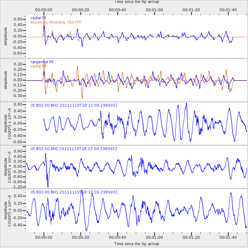
BOZ Bozeman, Montana, USA - Earthquake Result Viewer
*The percent match for this event was below the threshold and hence no stack was calculated.
| Earthquake location: |
Andreanof Islands, Aleutian Is. |
| Earthquake latitude/longitude: |
53.1/-174.1 |
| Earthquake time(UTC): |
2011/11/19 (323) 18:06:24 GMT |
| Earthquake Depth: |
215 km |
| Earthquake Magnitude: |
5.5 MW, 5.6 MW |
| Earthquake Catalog/Contributor: |
NEIC PDE/NEIC PDE-M |
|
| Network: |
US United States National Seismic Network |
| Station: |
BOZ Bozeman, Montana, USA |
| Lat/Lon: |
45.65 N/111.63 W |
| Elevation: |
1589 m |
|
| Distance: |
40.2 deg |
| Az: |
74.638 deg |
| Baz: |
304.081 deg |
| Ray Param: |
$rayparam |
*The percent match for this event was below the threshold and hence was not used in the summary stack. |
|
| Radial Match: |
59.51309 % |
| Radial Bump: |
362 |
| Transverse Match: |
42.004776 % |
| Transverse Bump: |
309 |
| SOD ConfigId: |
558545 |
| Insert Time: |
2013-09-19 06:53:31.949 +0000 |
| GWidth: |
2.5 |
| Max Bumps: |
400 |
| Tol: |
0.001 |
|
Signal To Noise
| Channel | StoN | STA | LTA |
| US:BOZ:00:BHZ:20111119T18:13:09.298993Z | 4.374674 | 4.7999066E-7 | 1.0972034E-7 |
| US:BOZ:00:BH1:20111119T18:13:09.298993Z | 0.9298102 | 1.83123E-7 | 1.9694664E-7 |
| US:BOZ:00:BH2:20111119T18:13:09.298993Z | 1.3836601 | 2.090089E-7 | 1.5105509E-7 |
| Arrivals |
| Ps | |
| PpPs | |
| PsPs/PpSs | |


