You are here: Home > Network List > IU - Global Seismograph Network (GSN - IRIS/USGS) Stations List
> Station PMG Port Moresby, New Guinea > Earthquake Result Viewer
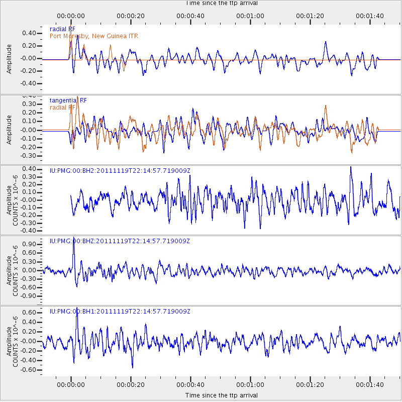
PMG Port Moresby, New Guinea - Earthquake Result Viewer
*The percent match for this event was below the threshold and hence no stack was calculated.
| Earthquake location: |
Kuril Islands |
| Earthquake latitude/longitude: |
46.6/151.5 |
| Earthquake time(UTC): |
2011/11/19 (323) 22:06:00 GMT |
| Earthquake Depth: |
96 km |
| Earthquake Magnitude: |
5.5 MB |
| Earthquake Catalog/Contributor: |
NEIC PDE/NEIC PDE-M |
|
| Network: |
IU Global Seismograph Network (GSN - IRIS/USGS) |
| Station: |
PMG Port Moresby, New Guinea |
| Lat/Lon: |
9.40 S/147.16 E |
| Elevation: |
90 m |
|
| Distance: |
55.9 deg |
| Az: |
185.188 deg |
| Baz: |
3.621 deg |
| Ray Param: |
$rayparam |
*The percent match for this event was below the threshold and hence was not used in the summary stack. |
|
| Radial Match: |
62.14372 % |
| Radial Bump: |
400 |
| Transverse Match: |
61.01356 % |
| Transverse Bump: |
400 |
| SOD ConfigId: |
558545 |
| Insert Time: |
2013-09-19 06:56:25.736 +0000 |
| GWidth: |
2.5 |
| Max Bumps: |
400 |
| Tol: |
0.001 |
|
Signal To Noise
| Channel | StoN | STA | LTA |
| IU:PMG:00:BHZ:20111119T22:14:57.719009Z | 4.502876 | 3.709488E-7 | 8.2380424E-8 |
| IU:PMG:00:BH1:20111119T22:14:57.719009Z | 2.6533184 | 2.58693E-7 | 9.749791E-8 |
| IU:PMG:00:BH2:20111119T22:14:57.719009Z | 1.4685087 | 1.2444245E-7 | 8.47407E-8 |
| Arrivals |
| Ps | |
| PpPs | |
| PsPs/PpSs | |


