You are here: Home > Network List > US - United States National Seismic Network Stations List
> Station BOZ Bozeman, Montana, USA > Earthquake Result Viewer
BOZ Bozeman, Montana, USA - Earthquake Result Viewer
*The percent match for this event was below the threshold and hence no stack was calculated.
| Earthquake location: |
Kuril Islands |
| Earthquake latitude/longitude: |
46.6/151.5 |
| Earthquake time(UTC): |
2011/11/19 (323) 22:06:00 GMT |
| Earthquake Depth: |
96 km |
| Earthquake Magnitude: |
5.5 MB |
| Earthquake Catalog/Contributor: |
NEIC PDE/NEIC PDE-M |
|
| Network: |
US United States National Seismic Network |
| Station: |
BOZ Bozeman, Montana, USA |
| Lat/Lon: |
45.65 N/111.63 W |
| Elevation: |
1589 m |
|
| Distance: |
62.7 deg |
| Az: |
51.605 deg |
| Baz: |
309.639 deg |
| Ray Param: |
$rayparam |
*The percent match for this event was below the threshold and hence was not used in the summary stack. |
|
| Radial Match: |
44.229446 % |
| Radial Bump: |
400 |
| Transverse Match: |
67.46389 % |
| Transverse Bump: |
400 |
| SOD ConfigId: |
558545 |
| Insert Time: |
2013-09-19 06:56:58.731 +0000 |
| GWidth: |
2.5 |
| Max Bumps: |
400 |
| Tol: |
0.001 |
|
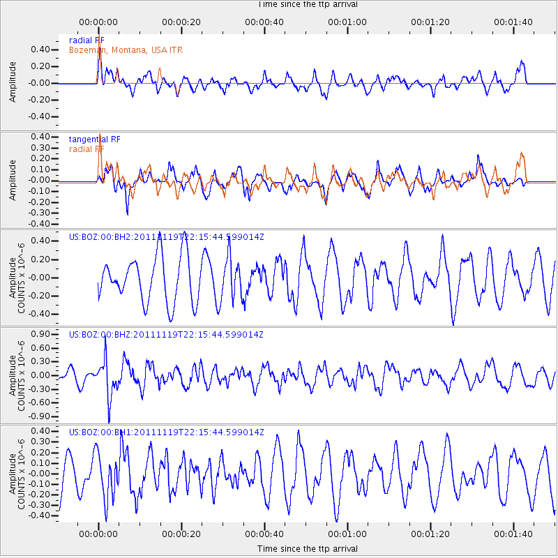
Signal To Noise
| Channel | StoN | STA | LTA |
| US:BOZ:00:BHZ:20111119T22:15:44.599014Z | 2.5633159 | 4.0388298E-7 | 1.5756271E-7 |
| US:BOZ:00:BH1:20111119T22:15:44.599014Z | 0.8307478 | 2.1439183E-7 | 2.580709E-7 |
| US:BOZ:00:BH2:20111119T22:15:44.599014Z | 0.94854856 | 2.3710855E-7 | 2.4996987E-7 |
| Arrivals |
| Ps | |
| PpPs | |
| PsPs/PpSs | |


