You are here: Home > Network List > II - Global Seismograph Network (GSN - IRIS/IDA) Stations List
> Station WRAB Tennant Creek, NT, Australia > Earthquake Result Viewer
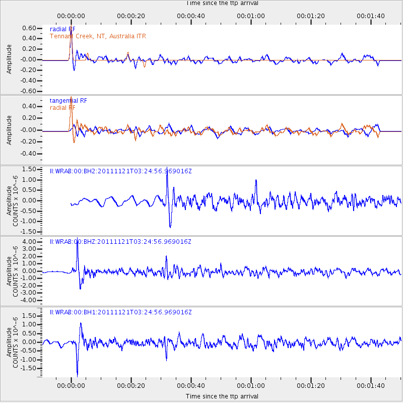
WRAB Tennant Creek, NT, Australia - Earthquake Result Viewer
*The percent match for this event was below the threshold and hence no stack was calculated.
| Earthquake location: |
Myanmar |
| Earthquake latitude/longitude: |
25.0/95.2 |
| Earthquake time(UTC): |
2011/11/21 (325) 03:15:42 GMT |
| Earthquake Depth: |
114 km |
| Earthquake Magnitude: |
5.9 MB, 5.7 MW, 5.7 MW |
| Earthquake Catalog/Contributor: |
WHDF/NEIC |
|
| Network: |
II Global Seismograph Network (GSN - IRIS/IDA) |
| Station: |
WRAB Tennant Creek, NT, Australia |
| Lat/Lon: |
19.93 S/134.36 E |
| Elevation: |
366 m |
|
| Distance: |
58.6 deg |
| Az: |
135.959 deg |
| Baz: |
317.878 deg |
| Ray Param: |
$rayparam |
*The percent match for this event was below the threshold and hence was not used in the summary stack. |
|
| Radial Match: |
69.483696 % |
| Radial Bump: |
400 |
| Transverse Match: |
65.99529 % |
| Transverse Bump: |
400 |
| SOD ConfigId: |
558545 |
| Insert Time: |
2013-09-19 07:00:49.937 +0000 |
| GWidth: |
2.5 |
| Max Bumps: |
400 |
| Tol: |
0.001 |
|
Signal To Noise
| Channel | StoN | STA | LTA |
| II:WRAB:00:BHZ:20111121T03:24:56.969016Z | 9.43095 | 1.3550117E-6 | 1.4367713E-7 |
| II:WRAB:00:BH1:20111121T03:24:56.969016Z | 6.1098466 | 6.1192185E-7 | 1.00153386E-7 |
| II:WRAB:00:BH2:20111121T03:24:56.969016Z | 4.3716593 | 5.9097033E-7 | 1.3518216E-7 |
| Arrivals |
| Ps | |
| PpPs | |
| PsPs/PpSs | |


