You are here: Home > Network List > IU - Global Seismograph Network (GSN - IRIS/USGS) Stations List
> Station HNR Honiara, Solomon Islands > Earthquake Result Viewer
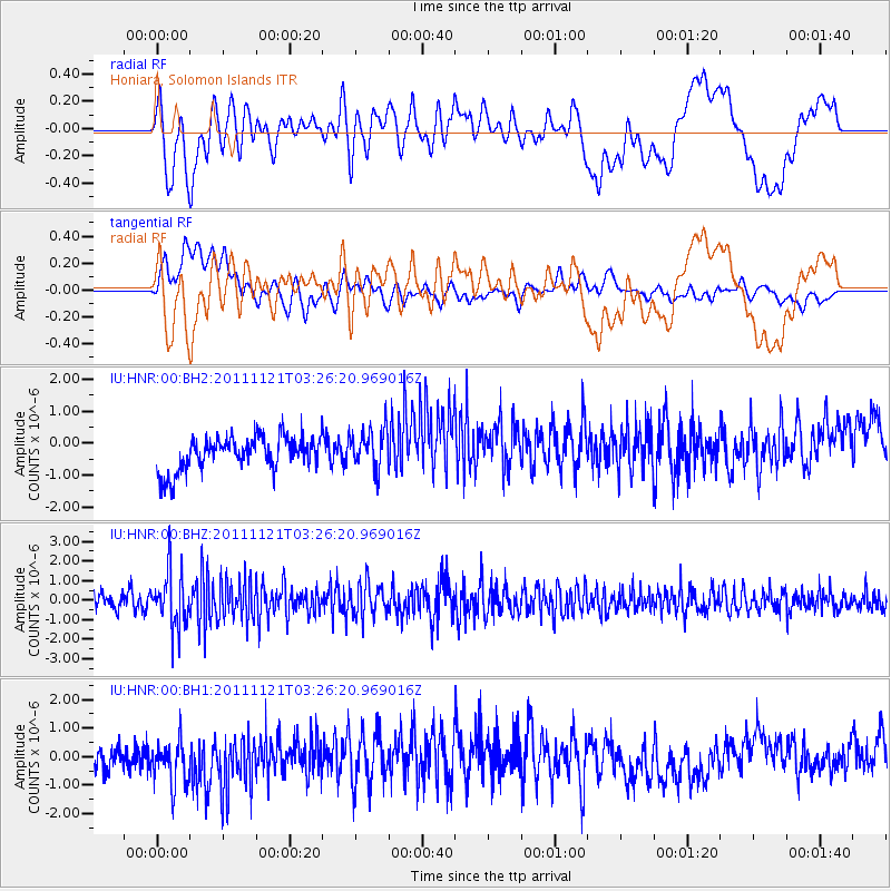
HNR Honiara, Solomon Islands - Earthquake Result Viewer
*The percent match for this event was below the threshold and hence no stack was calculated.
| Earthquake location: |
Myanmar |
| Earthquake latitude/longitude: |
25.0/95.2 |
| Earthquake time(UTC): |
2011/11/21 (325) 03:15:42 GMT |
| Earthquake Depth: |
114 km |
| Earthquake Magnitude: |
5.9 MB, 5.7 MW, 5.7 MW |
| Earthquake Catalog/Contributor: |
WHDF/NEIC |
|
| Network: |
IU Global Seismograph Network (GSN - IRIS/USGS) |
| Station: |
HNR Honiara, Solomon Islands |
| Lat/Lon: |
9.44 S/159.95 E |
| Elevation: |
100 m |
|
| Distance: |
71.7 deg |
| Az: |
110.002 deg |
| Baz: |
300.172 deg |
| Ray Param: |
$rayparam |
*The percent match for this event was below the threshold and hence was not used in the summary stack. |
|
| Radial Match: |
45.722046 % |
| Radial Bump: |
400 |
| Transverse Match: |
50.34999 % |
| Transverse Bump: |
400 |
| SOD ConfigId: |
558545 |
| Insert Time: |
2013-09-19 07:01:08.212 +0000 |
| GWidth: |
2.5 |
| Max Bumps: |
400 |
| Tol: |
0.001 |
|
Signal To Noise
| Channel | StoN | STA | LTA |
| IU:HNR:00:BHZ:20111121T03:26:20.969016Z | 3.5024 | 1.4202327E-6 | 4.0550273E-7 |
| IU:HNR:00:BH1:20111121T03:26:20.969016Z | 1.6292406 | 9.318597E-7 | 5.719595E-7 |
| IU:HNR:00:BH2:20111121T03:26:20.969016Z | 1.2001995 | 6.405349E-7 | 5.3369035E-7 |
| Arrivals |
| Ps | |
| PpPs | |
| PsPs/PpSs | |


