You are here: Home > Network List > US - United States National Seismic Network Stations List
> Station BOZ Bozeman, Montana, USA > Earthquake Result Viewer
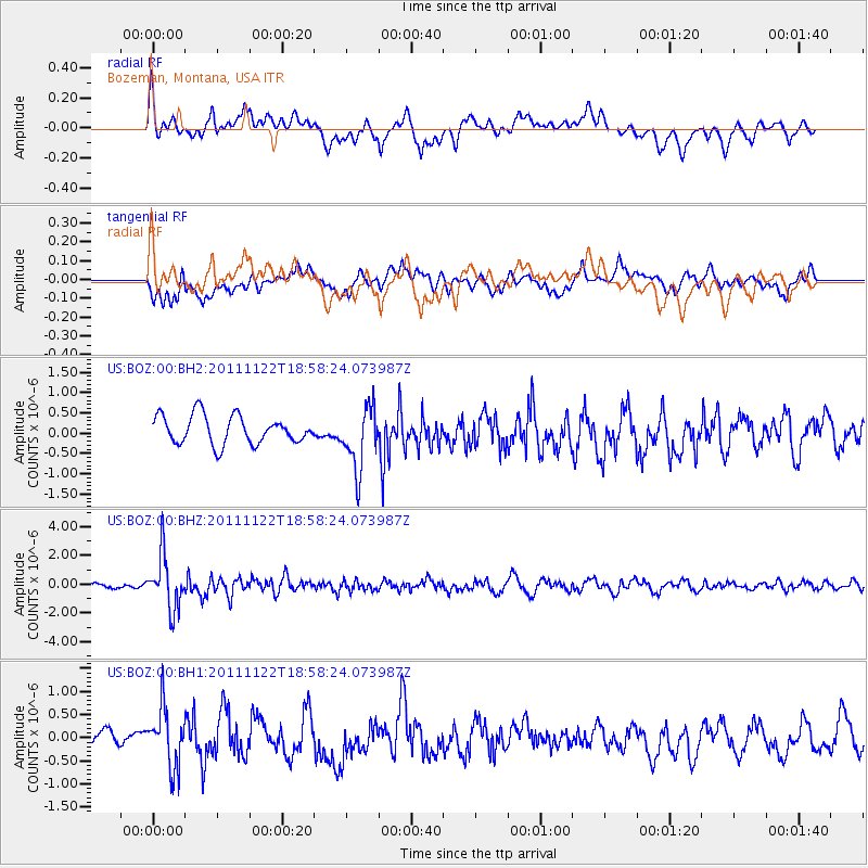
BOZ Bozeman, Montana, USA - Earthquake Result Viewer
*The percent match for this event was below the threshold and hence no stack was calculated.
| Earthquake location: |
Central Bolivia |
| Earthquake latitude/longitude: |
-15.4/-65.1 |
| Earthquake time(UTC): |
2011/11/22 (326) 18:48:16 GMT |
| Earthquake Depth: |
550 km |
| Earthquake Magnitude: |
6.2 MB, 6.6 MW, 6.6 MW |
| Earthquake Catalog/Contributor: |
WHDF/NEIC |
|
| Network: |
US United States National Seismic Network |
| Station: |
BOZ Bozeman, Montana, USA |
| Lat/Lon: |
45.65 N/111.63 W |
| Elevation: |
1589 m |
|
| Distance: |
73.9 deg |
| Az: |
327.992 deg |
| Baz: |
133.203 deg |
| Ray Param: |
$rayparam |
*The percent match for this event was below the threshold and hence was not used in the summary stack. |
|
| Radial Match: |
58.95676 % |
| Radial Bump: |
400 |
| Transverse Match: |
58.929604 % |
| Transverse Bump: |
400 |
| SOD ConfigId: |
558545 |
| Insert Time: |
2013-09-19 07:04:30.951 +0000 |
| GWidth: |
2.5 |
| Max Bumps: |
400 |
| Tol: |
0.001 |
|
Signal To Noise
| Channel | StoN | STA | LTA |
| US:BOZ:00:BHZ:20111122T18:58:24.073987Z | 5.2697897 | 1.8655453E-6 | 3.5400754E-7 |
| US:BOZ:00:BH1:20111122T18:58:24.073987Z | 2.6197724 | 6.3926205E-7 | 2.4401433E-7 |
| US:BOZ:00:BH2:20111122T18:58:24.073987Z | 2.2290974 | 7.691233E-7 | 3.45038E-7 |
| Arrivals |
| Ps | |
| PpPs | |
| PsPs/PpSs | |


