You are here: Home > Network List > US - United States National Seismic Network Stations List
> Station DGMT Dagmar, Montana, USA > Earthquake Result Viewer
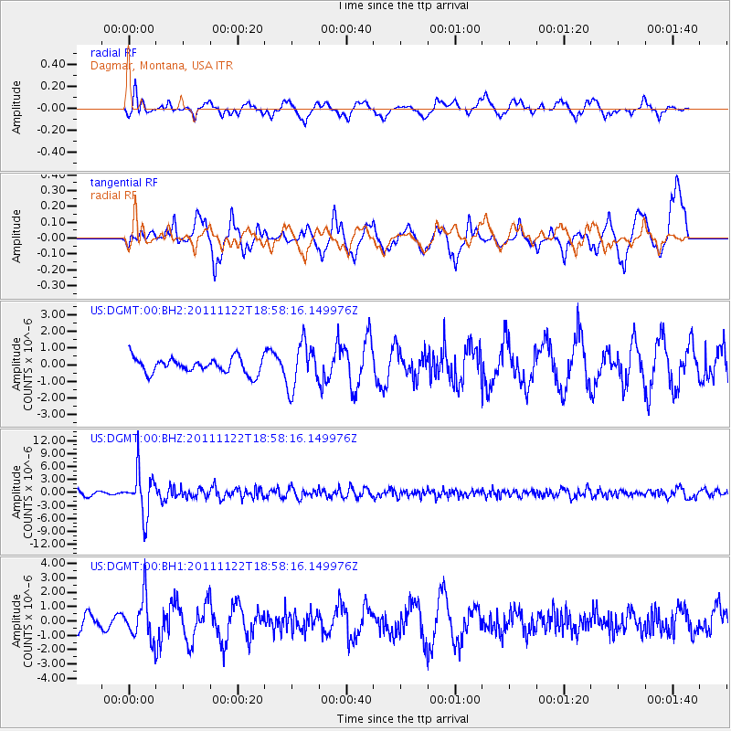
DGMT Dagmar, Montana, USA - Earthquake Result Viewer
*The percent match for this event was below the threshold and hence no stack was calculated.
| Earthquake location: |
Central Bolivia |
| Earthquake latitude/longitude: |
-15.4/-65.1 |
| Earthquake time(UTC): |
2011/11/22 (326) 18:48:16 GMT |
| Earthquake Depth: |
550 km |
| Earthquake Magnitude: |
6.2 MB, 6.6 MW, 6.6 MW |
| Earthquake Catalog/Contributor: |
WHDF/NEIC |
|
| Network: |
US United States National Seismic Network |
| Station: |
DGMT Dagmar, Montana, USA |
| Lat/Lon: |
48.47 N/104.20 W |
| Elevation: |
0.0 m |
|
| Distance: |
72.4 deg |
| Az: |
333.879 deg |
| Baz: |
140.34 deg |
| Ray Param: |
$rayparam |
*The percent match for this event was below the threshold and hence was not used in the summary stack. |
|
| Radial Match: |
50.332905 % |
| Radial Bump: |
400 |
| Transverse Match: |
53.66147 % |
| Transverse Bump: |
396 |
| SOD ConfigId: |
558545 |
| Insert Time: |
2013-09-19 07:04:48.217 +0000 |
| GWidth: |
2.5 |
| Max Bumps: |
400 |
| Tol: |
0.001 |
|
Signal To Noise
| Channel | StoN | STA | LTA |
| US:DGMT:00:BHZ:20111122T18:58:16.149976Z | 10.295394 | 4.9933556E-6 | 4.8500874E-7 |
| US:DGMT:00:BH1:20111122T18:58:16.149976Z | 2.1041906 | 1.4650467E-6 | 6.9625196E-7 |
| US:DGMT:00:BH2:20111122T18:58:16.149976Z | 2.9908147 | 1.3668756E-6 | 4.570245E-7 |
| Arrivals |
| Ps | |
| PpPs | |
| PsPs/PpSs | |


