You are here: Home > Network List > US - United States National Seismic Network Stations List
> Station EGMT Eagleton, Montana, USA > Earthquake Result Viewer
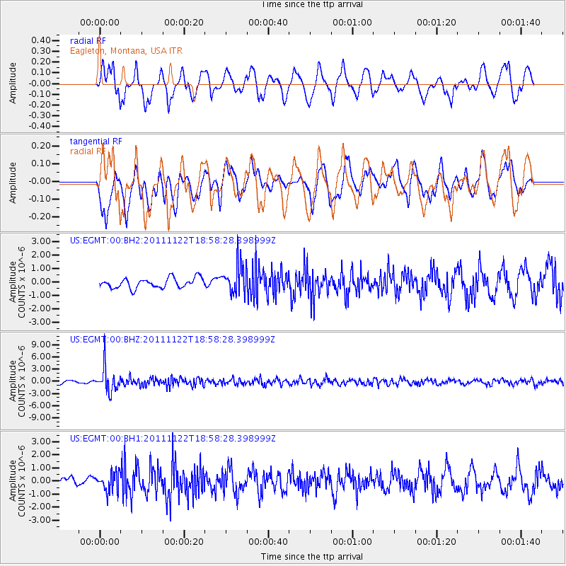
EGMT Eagleton, Montana, USA - Earthquake Result Viewer
*The percent match for this event was below the threshold and hence no stack was calculated.
| Earthquake location: |
Central Bolivia |
| Earthquake latitude/longitude: |
-15.4/-65.1 |
| Earthquake time(UTC): |
2011/11/22 (326) 18:48:16 GMT |
| Earthquake Depth: |
550 km |
| Earthquake Magnitude: |
6.2 MB, 6.6 MW, 6.6 MW |
| Earthquake Catalog/Contributor: |
WHDF/NEIC |
|
| Network: |
US United States National Seismic Network |
| Station: |
EGMT Eagleton, Montana, USA |
| Lat/Lon: |
48.02 N/109.75 W |
| Elevation: |
1055 m |
|
| Distance: |
74.6 deg |
| Az: |
330.695 deg |
| Baz: |
135.301 deg |
| Ray Param: |
$rayparam |
*The percent match for this event was below the threshold and hence was not used in the summary stack. |
|
| Radial Match: |
65.1111 % |
| Radial Bump: |
400 |
| Transverse Match: |
57.09916 % |
| Transverse Bump: |
400 |
| SOD ConfigId: |
558545 |
| Insert Time: |
2013-09-19 07:04:57.735 +0000 |
| GWidth: |
2.5 |
| Max Bumps: |
400 |
| Tol: |
0.001 |
|
Signal To Noise
| Channel | StoN | STA | LTA |
| US:EGMT:00:BHZ:20111122T18:58:28.398999Z | 8.055245 | 3.0953827E-6 | 3.8426919E-7 |
| US:EGMT:00:BH1:20111122T18:58:28.398999Z | 1.3986664 | 7.1053347E-7 | 5.080078E-7 |
| US:EGMT:00:BH2:20111122T18:58:28.398999Z | 3.152818 | 1.1646961E-6 | 3.694143E-7 |
| Arrivals |
| Ps | |
| PpPs | |
| PsPs/PpSs | |


