You are here: Home > Network List > CB - China National Seismic Network Stations List
> Station TIA Taian,Shandong Province > Earthquake Result Viewer
TIA Taian,Shandong Province - Earthquake Result Viewer
| Earthquake location: |
Southern Molucca Sea |
| Earthquake latitude/longitude: |
-0.2/125.2 |
| Earthquake time(UTC): |
2014/09/10 (253) 02:46:06 GMT |
| Earthquake Depth: |
30 km |
| Earthquake Magnitude: |
6.2 MWW, 6.1 MWB, 6.5 MI |
| Earthquake Catalog/Contributor: |
NEIC PDE/NEIC COMCAT |
|
| Network: |
CB China National Seismic Network |
| Station: |
TIA Taian,Shandong Province |
| Lat/Lon: |
36.21 N/117.12 E |
| Elevation: |
267 m |
|
| Distance: |
37.0 deg |
| Az: |
349.149 deg |
| Baz: |
166.539 deg |
| Ray Param: |
0.07633415 |
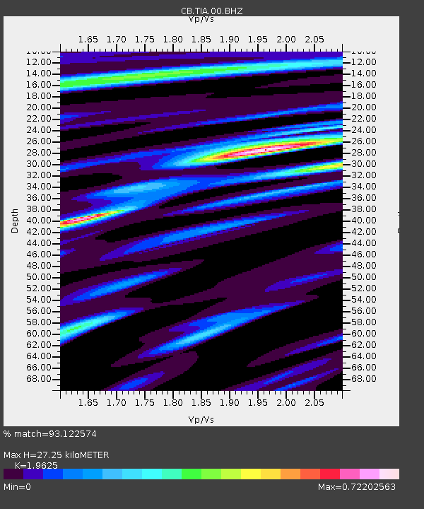
| Estimated Moho Depth: |
27.25 km |
| Estimated Crust Vp/Vs: |
1.96 |
| Assumed Crust Vp: |
6.363 km/s |
| Estimated Crust Vs: |
3.242 km/s |
| Estimated Crust Poisson's Ratio: |
0.32 |
|
| Radial Match: |
93.122574 % |
| Radial Bump: |
266 |
| Transverse Match: |
64.14707 % |
| Transverse Bump: |
400 |
| SOD ConfigId: |
3390531 |
| Insert Time: |
2019-04-13 23:02:37.331 +0000 |
| GWidth: |
2.5 |
| Max Bumps: |
400 |
| Tol: |
0.001 |
|

Signal To Noise
| Channel | StoN | STA | LTA |
| CB:TIA:00:BHZ:20140910T02:52:43.420001Z | 16.99178 | 1.1168484E-6 | 6.572874E-8 |
| CB:TIA:00:BHN:20140910T02:52:43.420001Z | 15.87202 | 7.275771E-7 | 4.5840235E-8 |
| CB:TIA:00:BHE:20140910T02:52:43.420001Z | 3.1785192 | 2.13926E-7 | 6.730367E-8 |
| Arrivals |
| Ps | 4.4 SECOND |
| PpPs | 12 SECOND |
| PsPs/PpSs | 16 SECOND |


