You are here: Home > Network List > CN - Canadian National Seismograph Network Stations List
> Station LLLB LILLOOET, BC, CANADA ADA > Earthquake Result Viewer
LLLB LILLOOET, BC, CANADA ADA - Earthquake Result Viewer
| Earthquake location: |
Michoacan, Mexico |
| Earthquake latitude/longitude: |
18.2/-102.5 |
| Earthquake time(UTC): |
2000/08/09 (222) 11:41:47 GMT |
| Earthquake Depth: |
46 km |
| Earthquake Magnitude: |
6.1 MB, 6.5 MS, 6.5 MW, 6.4 MW |
| Earthquake Catalog/Contributor: |
WHDF/NEIC |
|
| Network: |
CN Canadian National Seismograph Network |
| Station: |
LLLB LILLOOET, BC, CANADA ADA |
| Lat/Lon: |
50.61 N/121.88 W |
| Elevation: |
700 m |
|
| Distance: |
35.9 deg |
| Az: |
338.816 deg |
| Baz: |
147.374 deg |
| Ray Param: |
0.07689012 |
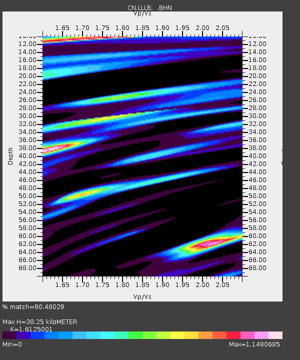
| Estimated Moho Depth: |
38.25 km |
| Estimated Crust Vp/Vs: |
1.61 |
| Assumed Crust Vp: |
6.597 km/s |
| Estimated Crust Vs: |
4.091 km/s |
| Estimated Crust Poisson's Ratio: |
0.19 |
|
| Radial Match: |
90.48029 % |
| Radial Bump: |
400 |
| Transverse Match: |
84.48956 % |
| Transverse Bump: |
400 |
| SOD ConfigId: |
3744 |
| Insert Time: |
2010-02-27 06:34:25.967 +0000 |
| GWidth: |
2.5 |
| Max Bumps: |
400 |
| Tol: |
0.001 |
|
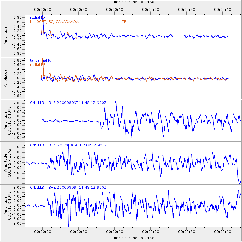
Signal To Noise
| Channel | StoN | STA | LTA |
| CN:LLLB: :BHN:20000809T11:48:12.900Z | 4.1400933 | 1537.2087 | 371.2981 |
| CN:LLLB: :BHE:20000809T11:48:12.900Z | 7.3080926 | 1700.6606 | 232.70924 |
| CN:LLLB: :BHZ:20000809T11:48:12.900Z | 9.681288 | 3322.6392 | 343.20215 |
| Arrivals |
| Ps | 3.9 SECOND |
| PpPs | 14 SECOND |
| PsPs/PpSs | 18 SECOND |


